| Little Red River | |
|---|---|
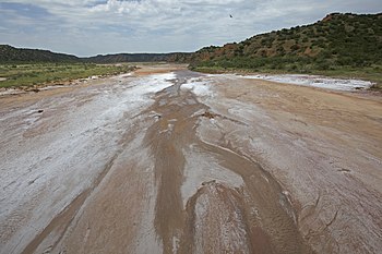
 Salty bed and red bluffs, Little Red River, Hall County, Texas | |
 | |
| Physical characteristics | |
| Source | |
| • location | Briscoe County, Texas |
| • coordinates | 34°27′01″N 101°03′05″W / 34.4503416°N 101.0512593°W[1] |
| • elevation | 2,282 ft (696 m) |
| Mouth | |
• location | Hall County, Texas |
• coordinates | 34°33′59″N 100°36′19″W / 34.5664465°N 100.6054053°W[1] |
• elevation | 1,839 ft (561 m) |
| Length | 30 mi (48 km) |
| Basin features | |
| River system | Red River of the South |
| Tributaries | |
| • left | North Prong Little Red River |
| • right | South Prong Little Red River |

The Little Red River is an intermittent stream about 30 mi (48 km) long, formed at the confluence of the North Prong and South Prong Little Red River in Briscoe County, Texas, and flowing east-northeastward to join the Prairie Dog Town Fork Red River in Hall County, Texas.[2]
