Back Lokeren Afrikaans Локерен Bulgarian Lokeren Breton Lokeren Catalan Lokeren (parokya) CEB Lokeren Czech Lokeren Danish Lokeren German Λόκερεν Greek Lokeren Esperanto
This article needs additional citations for verification. (February 2015) |
Lokeren | |
|---|---|
City and municipality | |
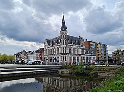
 The Old Postoffice of Lokeren | |
Location in Belgium
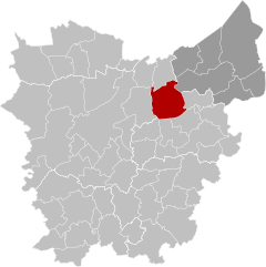
Location of Lokeren in East Flanders | |
| Coordinates: 51°06′N 03°59′E / 51.100°N 3.983°E | |
| Country | |
| Community | Flemish Community |
| Region | Flemish Region |
| Province | East Flanders |
| Arrondissement | Sint-Niklaas |
| Government | |
| • Mayor | Filip Anthuenis ( Open VLD) |
| • Governing party/ies | Open VLD, CD&V |
| Area | |
• Total | 68.24 km2 (26.35 sq mi) |
| Population (2022-01-01)[1] | |
• Total | 42,703 |
| • Density | 630/km2 (1,600/sq mi) |
| Postal codes | 9160 |
| NIS code | 46014 |
| Area codes | 09 |
| Website | www.lokeren.be |
Lokeren (Dutch pronunciation: [ˈloːkərə(n)] ⓘ) is a city and municipality located in the Belgian province of East Flanders, and belongs to the Waasland, also called Land van Waas, of which it is the second most important city after Sint-Niklaas. The city, located on the river Durme, the Lede, and the E17 motorway, has more than 42,100 inhabitants who are called Lokeraars or Rapenfretters. Because Lokeren is located on the Durme, Lokeren is often called "The Durme City". Horse sausages are officially recognized as a regional product.
- ^ "Bevolking per gemeente op 1 januari 2022". Statbel.


