Back لوميرا (ويسكونسن) Arabic Lomira Catalan Lomira CEB Lomira German Lomira (Wisconsin) Spanish Lomira French لومیرا (ويسکانسين) GLK Lomira, Wisconsin HT Lomira Italian Lomira (Wisconsin) LLD
Lomira, Wisconsin | |
|---|---|
 Downtown Lomira | |
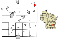
 Location of Lomira in Dodge County, Wisconsin. | |
| Coordinates: 43°34′39″N 88°26′50″W / 43.57750°N 88.44722°W | |
| Country | |
| State | |
| County | Dodge |
| Area | |
• Total | 2.15 sq mi (5.57 km2) |
| • Land | 2.14 sq mi (5.54 km2) |
| • Water | 0.01 sq mi (0.04 km2) |
| Elevation | 1,053 ft (321 m) |
| Population | |
• Total | 2,678 |
| • Density | 1,253.2/sq mi (483.8/km2) |
| Time zone | UTC-6 (Central (CST)) |
| • Summer (DST) | UTC-5 (CDT) |
| Area code | 920 |
| FIPS code | 55-45500[4] |
| GNIS feature ID | 1568503[2] |
| Website | www |
Lomira is a village in Dodge County, Wisconsin, United States. The population was 2,678 at the 2020 census.[3] The village is located within the Town of Lomira, at the crossroads of State Highways 49, 67 and 175, and Interstate 41.
- ^ "2020 U.S. Gazetteer Files". United States Census Bureau. Retrieved March 22, 2024.
- ^ a b U.S. Geological Survey Geographic Names Information System: Lomira, Wisconsin
- ^ a b "Profile of General Population and Housing Characteristics: 2020 Demographic Profile Data (DP-1): Lomira village, Wisconsin". United States Census Bureau. Retrieved March 22, 2024.
- ^ "U.S. Census website". United States Census Bureau. Retrieved January 31, 2008.