Back Lutherville-Timonium Catalan Lutherville-Timonium CEB Lutherville-Timonium (Maryland) Spanish Lutherville-Timonium (Maryland) Basque تیمونیوم، مریلند Persian Lutherville-Timonium French Люсервилл-Тимониум (Мэриленд) Kazakh Люсервилл-Тимониум (Мэриленд) Kirghiz Lutherville-Timonium Dutch Lutherville-Timonium Portuguese
Lutherville-Timonium, Maryland | |
|---|---|
Former census-designated place | |
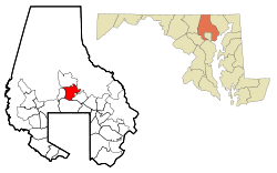
 Location of Lutherville-Timonium, Maryland | |
| Coordinates: 39°26′11″N 76°37′6″W / 39.43639°N 76.61833°W | |
| Country | |
| State | |
| County | |
| Area | |
• Total | 7.4 sq mi (19.1 km2) |
| • Land | 7.4 sq mi (19.1 km2) |
| • Water | 0.0 sq mi (0.0 km2) |
| Population (2000) | |
• Total | 15,814 |
| • Density | 2,142.1/sq mi (827.1/km2) |
| Time zone | UTC−5 (Eastern (EST)) |
| • Summer (DST) | UTC−4 (EDT) |
| ZIP codes | 21093-21094 |
| Area code(s) | 410, 443 |
| FIPS code | 24-48900 |
Lutherville-Timonium was a census-designated place (CDP) in Baltimore County, Maryland, United States, for the 2000 census. At that time the population was 15,814. For the 2010 census the area was split into two CDPs, the unincorporated communities of Lutherville and Timonium. Within its borders lies the Lutherville Historic District. The Maryland State Fair is held in Timonium each year near Labor Day.