Back مقاطعة لوزيرن (بنسيلفانيا) Arabic Luzerne County, Pennsylvania BAR Люцерн (окръг, Пенсилвания) Bulgarian লুজের্নে কাউন্টি, পেনসিলভানিয়া BPY Luzerne Gông (Pennsylvania) CDO Luzerne County CEB Luzerne County, Pennsylvania Welsh Luzerne County German Condado de Luzerne Spanish Luzerne konderria (Pennsylvania) Basque
Luzerne County | |
|---|---|
 | |
 Topographical map of Luzerne County, Pennsylvania | |
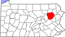
 Location of Luzerne County in Pennsylvania | |
| Country | United States |
| State | |
| Region | Northeastern Pennsylvania |
| Metro area | Wyoming Valley |
| Formed | September 25, 1786 |
| Named for | Chevalier de la Luzerne |
| County seat | Wilkes-Barre |
| Largest city | Wilkes-Barre |
| Government | |
| • Type | Council–manager |
| • Council | |
| • Council Chair | John Lombardo (R) |
| • Manager | Romilda Crocamo |
| Area | |
• Total | 906 sq mi (2,350 km2) |
| • Land | 890 sq mi (2,300 km2) |
| • Water | 16 sq mi (40 km2) |
| Highest elevation | 2,460 ft (750 m) |
| Lowest elevation | 512 ft (156 m) |
| Population (2020) | |
• Total | 325,594 |
| • Density | 360/sq mi (140/km2) |
| Time zone | UTC−5 (EST) |
| • Summer (DST) | UTC−4 (EDT) |
| Area codes | 570/272 |
| Website | www |
Luzerne County is a county in the Commonwealth of Pennsylvania. According to the United States Census Bureau, the county has a total area of 906 square miles (2,350 km2), of which 890 square miles (2,300 km2) is land and 16 square miles (41 km2) is water. It is Northeastern Pennsylvania's second-largest county by total area. As of the 2020 census, the population was 325,594, making it the most populous county in the northeastern part of the state. The county seat and most populous city is Wilkes-Barre.[1] Other populous communities include Hazleton, Kingston, Nanticoke, and Pittston. Luzerne County is included in the Scranton–Wilkes-Barre–Hazleton Metropolitan Statistical Area, which has a total population of 555,426 as of 2017. The county is part of the Northeast Pennsylvania region of the state.[a]
On September 25, 1786, Luzerne County was formed from part of Northumberland County. It was named after Chevalier de la Luzerne, a French soldier and diplomat during the 18th century. When it was founded, Luzerne County occupied a large portion of Northeastern Pennsylvania. From 1810 to 1878, it was divided into several smaller counties. The counties of Bradford, Lackawanna, Susquehanna, and Wyoming were all formed from parts of Luzerne County.[2][3]
The county gained prominence in the 19th and 20th centuries as an active anthracite coal mining region, drawing a large portion of its labor force from European immigrants. At its peak in 1930, the county's population was 445,109. Many factories and coal mines closed by the early 21st century. Like most regions in the Rust Belt, Luzerne County witnessed population loss and urban decay. However, in recent years, the economy has grown moderately; warehousing has replaced manufacturing as the main industry.[4]
- ^ "Find a County". National Association of Counties. Retrieved June 7, 2011.
- ^ Tice, Joyce M. "History of Bradford County PA, 1770–1878 by David Craft – Chapter 9". www.joycetice.com.
- ^ "Wyoming County Historical Society". pawchs.org.
- ^ Davidson, Adam (July 6, 2016). "Blaming Trade and Voting Trump in the Rust Belt". The New York Times. Retrieved January 19, 2018.
Cite error: There are <ref group=lower-alpha> tags or {{efn}} templates on this page, but the references will not show without a {{reflist|group=lower-alpha}} template or {{notelist}} template (see the help page).
