Back ليونز (كولورادو) Arabic ليونز ARZ لیونز، کولورادو AZB Лайънс Bulgarian Lyons (Colorado) Catalan Лайонс (Колорадо) CE Lyons (lungsod sa Tinipong Bansa, Colorado) CEB Lyons, Colorado Welsh Lyons (Colorado) Spanish Lyons (Colorado) Basque
Lyons, Colorado | |
|---|---|
 Downtown Lyons toward the intersection of U.S. Highway 36 and State Highway 7 | |
| Nickname: Double Gateway to the Rockies[2] | |
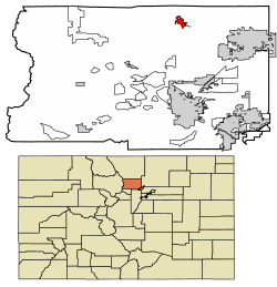
 Location of Lyons in Boulder County, Colorado. | |
| Coordinates: 40°13′06″N 105°15′02″W / 40.21833°N 105.25056°W | |
| Country | |
| State | |
| County[1] | Boulder |
| Founded | 1880 |
| Platted | 1881 |
| Incorporated (town) | April 10, 1891[3] |
| Founded by | Edward S. Lyon |
| Government | |
| • Type | Statutory Town[1] |
| • Mayor | Hollie Rogin [4] |
| Area | |
• Total | 3.53 km2 (1.36 sq mi) |
| • Land | 3.49 km2 (1.35 sq mi) |
| • Water | 0.04 km2 (0.01 sq mi) |
| Elevation | 1,628 m (5,341 ft) |
| Population (2020) | |
• Total | 2,209 |
| • Density | 627.78/km2 (1,626.30/sq mi) |
| Time zone | UTC-7 (Mountain (MST)) |
| • Summer (DST) | UTC-6 (MDT) |
| ZIP code[7] | 80540 |
| Area code | 303 & 720 |
| FIPS code | 08-47070 |
| GNIS feature ID | 2412930[6] |
| Website | www |
Lyons is a Statutory Town in Boulder County, Colorado, United States. The town population was 2,209 at the 2020 United States Census, up from 2,033 at the 2010 United States Census.[8] Lyons is located at the confluence of North St. Vrain Creek and South St. Vrain Creek, 20 miles (32 km) east of Rocky Mountain National Park. Due to its location at the intersection of State Highway 7 and U.S. Highway 36 which lead to Rocky Mountain National Park, it is sometimes referred to as "The Double Gateway to the Rockies".[2]
- ^ a b "Active Colorado Municipalities". State of Colorado, Department of Local Affairs. Archived from the original on December 12, 2009. Retrieved September 1, 2007.
- ^ a b Town of Lyons official site
- ^ "Colorado Municipal Incorporations". State of Colorado, Department of Personnel & Administration, Colorado State Archives. December 1, 2004. Retrieved September 2, 2007.
- ^ "Town Government". Town of Lyons. Retrieved June 18, 2016.
- ^ "2019 U.S. Gazetteer Files". United States Census Bureau. Retrieved July 1, 2020.
- ^ a b U.S. Geological Survey Geographic Names Information System: Lyons, Colorado
- ^ "ZIP Code Lookup". United States Postal Service. Archived from the original (JavaScript/HTML) on November 4, 2010. Retrieved November 16, 2007.
- ^ "Geographic Identifiers: 2010 Demographic Profile Data (G001): Lyons town, Colorado". U.S. Census Bureau, American Factfinder. Archived from the original on February 12, 2020. Retrieved September 26, 2013.