Back معاليه أدوميم Arabic معاليه ادوميم ARZ Ma'ale Adumim Catalan Ma'ale Adumim Czech Ma'ale Adumim Danish Maʿale Adummim German Μααλέ Αντουμίμ Greek Ma'ale Adumim Spanish Maale Adumin Basque معاله آدومیم Persian
Ma'ale Adumim
| |
|---|---|
City (from 1991) | |
| Hebrew transcription(s) | |
| • ISO 259 | Maˁle ʔadummim |
| • Also spelled | Ma'ale Adummim (official) |
 | |
| Coordinates: 31°46′30″N 35°17′53″E / 31.77500°N 35.29806°E | |
| Country | West Bank (de facto Israeli-occupied) |
| District | Judea and Samaria Area |
| Founded | September 21, 1975 |
| Government | |
| • Mayor | Benny Kashriel |
| Area | |
• Total | 49,177 dunams (49.177 km2 or 18.987 sq mi) |
| Population (2022)[1] | |
• Total | 38,046 |
| • Density | 770/km2 (2,000/sq mi) |
| Name meaning | Red ascent |
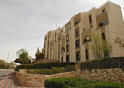
Ma'ale Adumim (Hebrew: מַעֲלֵה אֲדֻמִּים; Arabic: معالي أدوميم) is an urban Israeli settlement organized as a city council in the West Bank, seven kilometers (4.3 miles) east of Jerusalem. [2] Ma'ale Adumim achieved city status in 1991. In 2015, its population was 38,046. It is located along Highway 1, which connects it to Jerusalem and the Tel Aviv Metropolitan Area. The international community holds that Israeli settlements in the West Bank, within Israel, termed Judea and Samaria, are illegal under international law.[3] Israel does not agree with this view and the position of successive Israeli governments is that all authorized settlements are legal and consistent with international law.[4]
- ^ "Regional Statistics". Israel Central Bureau of Statistics. Retrieved 21 March 2024.
- ^ Benzaquen 2011.
- ^ "The Geneva Convention". BBC News. 10 December 2009. Retrieved 27 November 2010.
- ^ Gregory S. Mahler (2004). Politics and government in Israel: the maturation of a modern state. Rowman & Littlefield. p. 314. ISBN 978-0-7425-1611-3.

