Back نهر ماداواسكا (نهر) ARZ Madawaska (povodí řeky svatého Jana) Czech Madawaska River (New Brunswick) German Rivière Madawaska (fleuve Saint-Jean) French Мадаваска (приток Сент-Джона) Russian
This article needs additional citations for verification. (June 2016) |
| Madawaska River | |
|---|---|
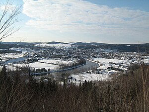
 Madawaska River in Degelis, Quebec, in winter | |
 | |
| Location | |
| Country | Canada |
| Cities | |
| Physical characteristics | |
| Source | |
| • location | Lake Témiscouata, Dégelis, Quebec, Temiscouata Regional County Municipality, Quebec |
| • coordinates | 47°34′14″N 68°38′33″W / 47.57056°N 68.64250°W |
| • elevation | 141 metres (463 ft) |
| Mouth | |
• location | Edmundston, New Brunswick |
• coordinates | 47°21′38″N 68°19′24″W / 47.36056°N 68.32333°W |
• elevation | 135 metres (443 ft) |
| Length | 39.8 kilometres (24.7 mi) |
| Basin features | |
| Tributaries | |
| • left | (from the mouth) Lynch Brook, Island Brook, Languedoc Brook, Lizotte Brook, Birch River (Madawaska River). |
| • right | (from the mouth) Troot River (Madawaska River), Griffin Brook, Perches River (Madawaska River). |
The Madawaska River flows from Lake Témiscouata in Quebec, through Degelis, Quebec, to join the Saint John River at Edmundston, New Brunswick.
The course of the Madawaska River is accessible in Quebec by route 185 and New Brunswick by Highway 2, which run along the river side South West.