Maitai | |
|---|---|
Suburb | |
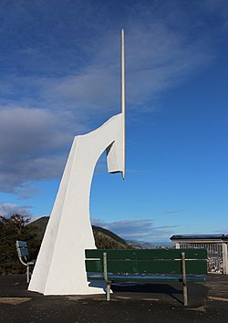
 Marker at Centre of New Zealand | |
 | |
| Coordinates: 41°16′30″S 173°17′50″E / 41.27500°S 173.29722°E | |
| Country | New Zealand |
| Region | Nelson |
| Ward |
|
| Electorates | |
| Government | |
| • Territorial Authority | Nelson City Council |
| • Nelson City Mayor | Nick Smith |
| • Nelson MP | Rachel Boyack |
| • Te Tai Tonga MP | Tākuta Ferris |
| Area | |
• Total | 0.94 km2 (0.36 sq mi) |
| • Land | 0.94 km2 (0.36 sq mi) |
| • Water | 0 km2 (0 sq mi) |
| Population (June 2024)[2] | |
• Total | 1,430 |
| • Density | 1,500/km2 (3,900/sq mi) |
| Time zone | UTC+12 (NZST) |
| • Summer (DST) | UTC+13 (NZDT) |
| Postcode | 7010 |
| Area code | 03 |
Maitai is an inner suburb of Nelson, New Zealand. It lies at the eastern edge of Nelson city centre, immediately to the south of The Wood, on the northern bank of the Maitai River. A monument representing the location of the geographic centre of New Zealand is located in Maitai.[3]
The population was 609 in the 2013 census. This was an increase of 9 people since the 2006 Census.[4]
- ^ Cite error: The named reference
Areawas invoked but never defined (see the help page). - ^ "Aotearoa Data Explorer". Statistics New Zealand. Retrieved 26 October 2024.
- ^ Wise's Nelson-Blenheim "Easyread" Map ISBN 1 877402 50 8
- ^ 2013 Census QuickStats about a place : Maitai
