Back مجدل شمس Arabic مجدل شمس ARZ Majdal Shams Catalan Madždal Šams Czech Madschdal Schams German Ματζντάλ Σαμς Greek Maĵdal Ŝams Esperanto Majdal Shams Spanish مجدل شمس Persian Majdal Šams Finnish
Majdal Shams
مجدل شمس | |
|---|---|
Town | |
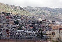
 Majdal Shams in May 2009 | |
| Coordinates: 33°16′N 35°46′E / 33.267°N 35.767°E | |
| Territory | Israeli-occupied Syrian territory (Golan Heights) |
| District (Israel) | Northern District |
| Subdistrict (Israel) | Golan Subdistrict |
| Governorate (Syria) | Quneitra Governorate |
| District (Syria) | Quneitra District |
| Government | |
| • Mayor | Dolan Abu Saleh (Majdala) |
| Elevation | 1,130 m (3,710 ft) |
| Population (2022)[1] | |
• Total | 11,458 |
| Website | https://www.majdal.co.il/ |
| Founded either at the end of the 16th, or during the 18th century[2] | |
Majdal Shams (Arabic: مجدل شمس; Hebrew: מַגְ'דַל שַׁמְס) is a predominantly Druze town in the Israeli-occupied Golan Heights,[3][4] located in the southern foothills of Mount Hermon. It is known as the informal "capital" of the region.
Majdal Shams played a significant role in the Great Syrian Revolt of 1925–1927 that was led by Druze leader Sultan Al-Atrash, who is commemorated by several monuments in the city. Beginning in the 1930s, Majdal Shams became involved in political developments in nearby Mandatory Palestine, and supported the Arab Palestinians during the 1948 Palestine war.
Since the 1967 Arab–Israeli War, Majdal Shams along with the broader Golan Heights have been under Israeli occupation,[5] and effectively annexed in 1981, in a move only recognized by the United States. The US recognition was lobbied by Israeli officials.[6]
Majdal Shams is the largest of the four remaining Syrian Druze communities in the Israeli-occupied territories of Golan Heights,[7] the other three being Ein Qiniyye, Mas'ade, and Buq'ata. While the Golan Heights and Mount Hermon are administratively joined, they differ geologically and geographically, with their boundary being marked by the Sa'ar Stream; Majdal Shams and Ein Qiniyye sit on limestone on the Hermon side, while Buq'ata and Mas'ade are on the Golan side, which is characterized by black volcanic rock (i.e., basalt).
- ^ "Regional Statistics". Israel Central Bureau of Statistics. Retrieved 21 March 2024.
- ^ Cite error: The named reference
Kirrishwas invoked but never defined (see the help page). - ^ Algemeiner, The (2024-07-27). "10 Dead, Many in Critical Condition After Hezbollah Rocket Hits Soccer Field in Druze Town - Algemeiner.com". www.algemeiner.com. Retrieved 2024-07-27.
- ^ Keller-Lyne, Carrie (2024-07-27). "Deadly Rocket Strike on Soccer Field Raises Risk of Escalation with Hezbollah". The Wall Street Journal.
- ^ "Golan Druze celebrate across barbed wire". BBC News. April 18, 2008. Retrieved May 12, 2010.
- ^ Wilner, Michael (2019-02-28). "GOP lawmakers introduce bill recognizing Israeli sovereignty over Golan". The Jerusalem Post. Retrieved 2024-08-01.
- ^ Neuman, T. (2018). Settling Hebron: Jewish Fundamentalism in a Palestinian City. The Ethnography of Political Violence. University of Pennsylvania Press. p. 107. ISBN 978-0-8122-4995-8. Retrieved 2019-04-04.


