Back Straat van Makassar Afrikaans مضيق ماكاسار Arabic Estrechu de Macasar AST Makassar boğazı Azerbaijani Itiot nin Makassar BCL Макасарскі праліў Byelorussian Макасарски проток Bulgarian Selat Makassar BJN Makasarski prolaz BS Estret de Macassar Catalan
| Makassar Strait | |
|---|---|
| Selat Makassar (Indonesian) | |
 Makassar Strait Map | |
| Location | Indonesia |
| Coordinates | 0°0′0″N 118°30′00″E / 0.00000°N 118.50000°E |
| Type | strait |
| Basin countries | Indonesia |
| Islands | +100 |
| Settlements | Balikpapan, Bontang (Kalimantan) Makassar, Palu, Parepare (Sulawesi) |
| References | Macassar Strait: OS (Oceans) National Geospatial-Intelligence Agency, Bethesda, MD, USA |
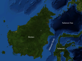
Makassar Strait (Indonesian: Selat Makassar) is a strait between the islands of Borneo and Sulawesi in Indonesia. To the north it joins the Celebes Sea, while to the south it meets the Java Sea. To the northeast, it forms the Sangkulirang Bay south of the Mangkalihat Peninsula. The strait is an important regional shipping route in Southeast Asia.
The Mahakam River and Karangan River of Borneo empty into the strait.
Ports along the strait include Balikpapan and Bontang in Borneo, and Makassar, Palu, and Parepare in Sulawesi. The city of Samarinda is 48 km (30 mi) from the strait, along the Mahakam.


