Back Maldon (District) BAR Maldon District CEB Ardal Maldon Welsh Maldon District German Maldon (district) French Maldon (distretto) Italian 몰던구 Korean Moldona (distrikts) Latvian/Lettish Maldon (district) Dutch Maldon (distrikt) NB
Maldon District | |
|---|---|
 Maldon, the administrative centre of the district | |
 Maldon shown within Essex | |
| Sovereign state | United Kingdom |
| Country | England |
| Region | East of England |
| Non-metropolitan county | Essex |
| Status | Non-metropolitan district |
| Admin HQ | Maldon |
| Founded | 1 April 1974 |
| Government | |
| • Type | Non-metropolitan district council |
| • Body | Maldon District Council |
| • MPs | Priti Patel John Whittingdale |
| Area | |
• Total | 138.53 sq mi (358.78 km2) |
| • Rank | 99th (of 296) |
| Population (2022) | |
• Total | 67,554 |
| • Rank | 287th (of 296) |
| • Density | 490/sq mi (190/km2) |
| Ethnicity (2021) | |
| • Ethnic groups | |
| Religion (2021) | |
| • Religion | List
|
| Time zone | UTC0 (GMT) |
| • Summer (DST) | UTC+1 (BST) |
| ONS code | 22UK (ONS) E07000074 (GSS) |
| OS grid reference | TL848070 |
Maldon District Council | |
|---|---|
 | |
| Type | |
| Type | |
| Leadership | |
Richard Siddall, Maldon Independents since 8 June 2023 | |
Doug Wilkinson since October 2024[4] | |
| Structure | |
| Seats | 31 |
Political groups |
|
| Elections | |
Last election | 4 May 2023 |
Next election | 2027 |
| Meeting place | |
 | |
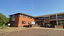
| Council Offices, Princes Road, Maldon, CM9 5DL | |
| Website | |
| www | |
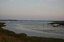
Maldon District is a local government district[5][6] in Essex, England. The district is managed by Maldon District Council, which is based in Maldon, the largest town in the district. The district also includes the town of Burnham-on-Crouch and numerous villages, including Heybridge, Wickham Bishops, Southminster, Tolleshunt D'Arcy and Tollesbury. The district covers the Dengie peninsula to the south of Maldon and the Thurstable Hundred area to the north of the Blackwater Estuary, a total area of 358.78 km2.[7]

The majority of people live in the small rural villages, many of which have their origins in connections with the coast or agricultural economy. The district has a long association with sailing, as is referenced in the council's logo.

- ^ a b UK Census (2021). "2021 Census Area Profile – Maldon Local Authority (E07000074)". Nomis. Office for National Statistics. Retrieved 5 January 2024.
- ^ "Council meeting, 18 May 2023". Maldon District Council. Retrieved 19 May 2023.
- ^ "Member appointments for the Municipal Year 2024/25". Maldon District Council. 20 May 2024. Retrieved 4 July 2024.
- ^ "Council minutes, 25 July 2019". Maldon District Council. Retrieved 7 June 2023.
- ^ "Maldon Town Council – Working for You". Retrieved 6 July 2021.
- ^ Council, Maldon District. "Maldon District Council". maldon.gov.uk. Retrieved 6 July 2021.
- ^ "Output Geography". statistics.gov.uk. Archived from the original on 2 January 2007. Retrieved 24 January 2007.