Back لا ريجيون اينسولار ديل پاسيفيكو فلورا واى فاونا ARZ Malpelo adası Azerbaijani Illa de Malpelo Catalan Isla Malpelo CEB Malpelo Czech Malpelo Danish Malpelo German Insulo Malpelo Esperanto Isla de Malpelo Spanish Malpelo uhartea Basque
Native name: Isla de Malpelo | |
|---|---|
 Profile of Malpelo Island | |
| Geography | |
| Location | Pacific Ocean |
| Coordinates | 04°00′12.038″N 81°36′27.259″W / 4.00334389°N 81.60757194°W |
| Area | 1.2 km2 (0.46 sq mi) |
| Length | 1.643 km (1.0209 mi) |
| Width | 0.727 km (0.4517 mi) |
| Highest elevation | 360 m (1180 ft) |
| Highest point | Cerro La Mona |
| Administration | |
| Department | Valle del Cauca |
| Municipality | Buenaventura |
| Demographics | |
| Population | Uninhabited |
| Official name | Malpelo Fauna and Flora Sanctuary |
| Type | Natural |
| Criteria | vii, ix |
| Designated | 2006 |
| Reference no. | 1216 |
| Region | Latin America and the Caribbean |

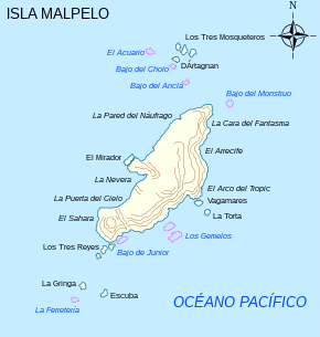
Malpelo is a small oceanic island in the eastern Pacific Ocean, located about 500 km (310 mi) west of the Colombian mainland with a military post manned by the Colombian Armed Forces. It consists of a sheer and barren rock with three high peaks, the highest being the 300 m (980 ft) Cerro de la Mona. The island is about 1.5 kilometres (1 mile) in length from northeast to southwest, and 640 metres (700 yards) across at its widest.

