Back جزيرة مالطا Arabic جزيرة مالطا ARZ Islla de Malta AST Malta adası Azerbaijani Мальта (востраў) Byelorussian Мальта (востраў) BE-X-OLD Malta (ostrvo) BS Illa de Malta Catalan Malta (ostrov) Czech Мальта утравĕ CV
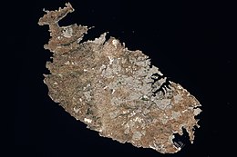
 Satellite image of Malta | |
 Map of the Maltese Archipelago highlighting the island of Malta | |
| Geography | |
|---|---|
| Location | South of Sicily, Mediterranean Sea |
| Coordinates | 35°53′N 14°27′E / 35.883°N 14.450°E |
| Archipelago | Maltese Archipelago |
| Total islands | 5 islands that surround Malta |
| Major islands | Filfa, St Paul's Islands, Manoel Island. |
| Area | 246 km2 (95 sq mi) |
| Coastline | 197 km (122.4 mi) |
| Highest elevation | 253 m (830 ft) |
| Highest point | Ta' Dmejrek |
| Administration | |
Malta | |
| Capital city | Valletta |
| Largest settlement | St. Paul's Bay (pop. 29,097) |
| Demographics | |
| Population | Approx. 500,000 (May 2021) |
| Pop. density | 1,664/km2 (4310/sq mi) |
| Ethnic groups | Maltese people |
Malta is an island in Southern Europe. It is the largest and most populous of the three major islands that constitute the Maltese Archipelago. The island is situated in the Mediterranean Sea directly south of Italy and north of Libya. It lies south-east of the smaller islands of Gozo and Comino.The island is 27 kilometres (17 mi) long and 14.5 kilometres (9 mi) wide, with a total area of 246 square kilometres (95 sq mi). The capital is Valletta, while the largest locality is Rabat. The island is made up of many small towns, which together form one larger urban zone with a population of 409,259. The landscape is characterised by low hills with terraced fields.