Back مقاطعة مانيتووك (ويسكونسن) Arabic Manitowoc County, Wisconsin BAR Манитуак (окръг, Уисконсин) Bulgarian মানিটোৱোক কাউন্টি, উইসকনসিন BPY Манитовок (гуо, Висконсин) CE Manitowoc County CEB Manitowoc County, Wisconsin Welsh Manitowoc County German Condado de Manitowoc Spanish Manitowoc konderria (Wisconsin) Basque
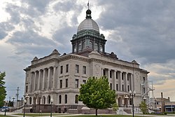
Manitowoc County, Wisconsin | |
|---|---|
 | |
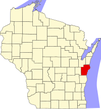
 Map of Wisconsin showing Manitowoc County | |
 Wisconsin's location in the United States | |
| Country | |
| State | |
| Incorporated | 1848 |
| County seat | City of Manitowoc |
| Incorporated Municipalities | 30 (total)
|
| Government | |
| • Type | County |
| • Body | Board of Supervisors |
| • Board Chairman | Tyler Martell[1] |
| • County Board | 25 commissioners |
| Area | |
• Total | 1,494 sq mi (3,870 km2) |
| • Land | 589 sq mi (1,530 km2) |
| • Water | 905 sq mi (2,340 km2) |
| • Rank | 6th largest county in Wisconsin |
| Population | |
• Total | 81,359 |
• Estimate (2023) | 81,331 |
| • Rank | 21st largest county in Wisconsin |
| • Density | 138.1/sq mi (53.3/km2) |
| Time zone | UTC−6 (Central) |
| • Summer (DST) | UTC−5 (Central) |
| Area codes | 920 |
| Congressional districts | 6th |
| Interstates | |
| U.S. Routes | |
| State Routes | |
| Airports | Manitowoc County Airport
|
| Waterways | Lake Michigan – Manitowoc River
|
| Public transit | Maritime Metro Transit |
| Website | manitowoccountywi |
Manitowoc County (/ˈmænɪtəwɒk/ ⓘ MAN-it-ə-wok) is a county in the U.S. state of Wisconsin. As of the 2020 census, the population was 81,359.[3] Its county seat is Manitowoc.[4] The county was created in 1836 prior to Wisconsin's statehood and organized in 1848.[5] Manitowoc County comprises the Manitowoc, WI Micropolitan Statistical Area.
- ^ "Tyler Martell". Manitowoc County. Retrieved August 5, 2024.
- ^ Cite error: The named reference
2020-census-55071was invoked but never defined (see the help page). - ^ "State & County QuickFacts". United States Census Bureau. Archived from the original on June 6, 2011. Retrieved January 22, 2014.
- ^ "Find a County". National Association of Counties. Retrieved June 7, 2011.
- ^ "Wisconsin: Individual County Chronologies". Wisconsin Atlas of Historical County Boundaries. The Newberry Library. 2007. Archived from the original on April 14, 2017. Retrieved August 15, 2015.

