Back Marcus Garvey Park Catalan Marcus Garvey Memorial Park CEB Marcus Garvey Park German Marcus Garvey Park Basque Marcus Garvey Park French Marcus Garvey Park ID 馬庫斯·加維公園 Chinese
| Marcus Garvey Park | |
|---|---|
| Mount Morris Park | |
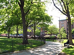
 View in the park looking west | |
 | |
| Location | Harlem/East Harlem, Manhattan |
| Nearest city | New York City |
| Coordinates | 40°48′16″N 73°56′37″W / 40.804487°N 73.943696°W |
| Area | 20.16 acres (8.16 ha) |
| Created | 1840 |
| Operated by | New York City Department of Parks and Recreation |
Marcus Garvey Park (formerly and also named Mount Morris Park) is a 20.16-acre (81,600 m2) park on the border between the Harlem and East Harlem neighborhoods of Manhattan, New York City. The park, centered on a massive and steep outcropping of schist, interrupts the flow of Fifth Avenue traffic,[a] which is routed around the park via Mount Morris Park West. The park is also bounded by 120th Street to the south, 124th Street to the north, and Madison Avenue to the east.
The park was created in 1840 and was originally named for Robert Morris, then the mayor of New York City. It was renamed after black activist and businessman Marcus Garvey in 1973. Marcus Garvey Park contains flat lawns and playing fields surrounding the schist outcropping, as well as the Harlem Fire Watchtower, a New York City designated landmark. It is operated and maintained by the New York City Department of Parks and Recreation.
Cite error: There are <ref group=lower-alpha> tags or {{efn}} templates on this page, but the references will not show without a {{reflist|group=lower-alpha}} template or {{notelist}} template (see the help page).