Back مقاطعة مارتن (إنديانا) Arabic Martin County, Indiana BAR Мартин (окръг, Индиана) Bulgarian মার্টিন কাউন্টি, ইন্ডিয়ানা BPY Martin Gông (Indiana) CDO Мартин (гуо, Индиана) CE Martin County (kondado sa Tinipong Bansa, Indiana) CEB Martin County, Indiana Welsh Martin County (Indiana) German Κομητεία Μάρτιν (Ιντιάνα) Greek
Martin County | |
|---|---|
 Martin County Courthouse | |
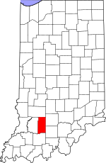
 Location within the U.S. state of Indiana | |
 Indiana's location within the U.S. | |
| Coordinates: 38°43′N 86°48′W / 38.71°N 86.8°W | |
| Country | |
| State | |
| Founded | January 20, 1820 |
| Named for | Major John T. Martin |
| Seat | Shoals |
| Largest city | Loogootee |
| Area | |
• Total | 340.41 sq mi (881.7 km2) |
| • Land | 335.74 sq mi (869.6 km2) |
| • Water | 4.67 sq mi (12.1 km2) 1.37% |
| Population (2020) | |
• Total | 9,812 |
• Estimate (2023) | 9,897 |
| • Density | 29/sq mi (11/km2) |
| Time zone | UTC−5 (Eastern) |
| • Summer (DST) | UTC−4 (EDT) |
| Congressional district | 8th |
| Website | martincountyindiana |
| Indiana county number 51 | |
Martin County is a county in the U.S. state of Indiana. As of the 2020 United States Census, the population was 9,812.[1] The county seat is Shoals at the center of the county,[2] and the county's only incorporated city is Loogootee, on the county's western border.[3]
- ^ 2020 census
- ^ "Find a County". National Association of Counties. Retrieved June 7, 2011.
- ^ Cite error: The named reference
MCIwas invoked but never defined (see the help page).