Back نهر ماري Arabic نهر مارى ARZ Mary River (Korallenmeer) German Río Mary Spanish Mary (Queensland) French Մերի (գետ) Armenian Mary River Dutch Мэри (река) Russian
| Mary Wide Bay | |
|---|---|
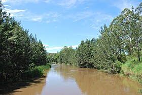
 The upper Mary River at Conondale | |
Location of Mary River mouth in Queensland | |
| Etymology | Lady Mary Lennox,[1] wife of Charles Augustus FitzRoy |
| Location | |
| Country | Australia |
| State | Queensland |
| Regions | South East Queensland, Wide Bay–Burnett |
| Physical characteristics | |
| Source | Conondale Range |
| • location | Conondale, South East Queensland |
| • coordinates | 26°47′39″S 152°44′41″E / 26.79417°S 152.74472°E |
| • elevation | 209 m (686 ft) |
| Mouth | Great Sandy Strait |
• location | River Heads, Wide Bay–Burnett |
• coordinates | 25°25′29″S 152°56′17″E / 25.4248°S 152.9380°E |
• elevation | 0 m (0 ft) |
| Length | 291 km (181 mi) |
| Basin size | 9,595 km2 (3,705 sq mi) |
| Discharge | |
| • location | Near mouth |
| • average | 55.4 m3/s (1,750 GL/a)[2] |
| Basin features | |
| Tributaries | |
| • left | Yabba Creek, Kandanga Creek, Widgee Creek, Wide Bay Creek, Munna Creek, Susan River |
| • right | Obi Obi Creek, Tinana Creek, Deep Creek, Six Mile Creek |
| Reservoir | Lake Borumba |
| [3] | |
The Mary River is a major river system in the South East and Wide Bay–Burnett regions of Queensland, Australia.[1] The Mary River is unique in that it flows south to north.[4]
The river is important because it is home to three threatened species, the Mary River turtle, white-throated snapping turtle and the Mary River cod.[4] The Mary River was to be dammed with the construction of the Traveston Crossing Dam until it was cancelled due to environmental reasons. The river has experienced major floods in 1955, 1992, 1999, 2011, 2013 and 2022.
- ^ a b Cite error: The named reference
QPNwas invoked but never defined (see the help page). - ^ "East Coastal Watersheds". Archived from the original on 17 June 2023. Retrieved 17 June 2023.
- ^ "Map of Mary River, QLD". Bonzle Digital Atlas of Australia. Archived from the original on 29 August 2016. Retrieved 14 November 2015.
- ^ a b Whiteside, Grace (13 October 2023). "Queensland's mighty Mary River and its endangered unique inhabitants face dry spell after last year's floods". ABC News. Archived from the original on 23 November 2023. Retrieved 22 November 2023.
