Back Matamata-Piako District CEB Matamata-Piako District German District de Matamata-Piako French Distretto di Matamata-Piako Italian Daerah Matamata-Piako Malay Matamata-Piako District NN Matamata-Piako (distrikt) NB ضلع سٹریٹفورڈ PNB
Matamata-Piako District | |
|---|---|
 Te Aroha | |
 Matamata-Piako district within the North Island | |
| Coordinates: 37°42′18″S 175°39′43″E / 37.705°S 175.662°E | |
| Country | New Zealand |
| Region | Waikato |
| Wards | Matamata Morrinsville Te Aroha Te Toa Horopū ā Matamata-Piako (Māori) |
| Seat | Te Aroha |
| Government | |
| • Mayor | Adrienne Wilcock |
| • Territorial authority | Matamata-Piako District Council |
| Area | |
| • Land | 1,755.35 km2 (677.74 sq mi) |
| Population (June 2024)[2] | |
• Total | 39,300 |
| Time zone | UTC+12 (NZST) |
| • Summer (DST) | UTC+13 (NZDT) |
| Postcode(s) | |
| Website | Matamata-Piako District Council |
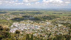
Matamata-Piako District is a local government area in the Waikato region of New Zealand. It lies to the east of the city of Hamilton.
- ^ Cite error: The named reference
Areawas invoked but never defined (see the help page). - ^ "Aotearoa Data Explorer". Statistics New Zealand. Retrieved 26 October 2024.