Back Mato Grosso ACE Mato Grosso Afrikaans ماتو غروسو Arabic Mato Grosso AST Mato Grosso Istadu Aymara Matu-Qrosu Azerbaijani Mato Grosso BAR Мату-Гросу Byelorussian Мату-Гросу BE-X-OLD Мато Гросо Bulgarian
Mato Grosso | |
|---|---|
|
| |
| Motto(s): | |
| Anthem: "Hino de Mato Grosso" | |
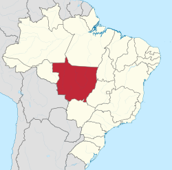
 Location of Mato Grosso (in red) in Brazil | |
| Coordinates: 15°34′00″S 56°04′30″W / 15.56667°S 56.07500°W | |
| Country | |
| Capital and largest city | Cuiabá |
| Government | |
| • Governor | Mauro Mendes (UNIÃO) |
| • Vice Governor | Otaviano Pivetta (Republicanos) |
| • Senators | Jayme Campos (UNIÃO) Margareth Buzetti (PP) Wellington Fagundes (PL) |
| Area | |
• Total | 903,357 km2 (348,788 sq mi) |
| • Rank | 3rd |
| Highest elevation | 902 m (2,959 ft) |
| Population (2022)[1] | |
• Total | 3,658,649 |
| • Rank | 17th |
| • Density | 4.1/km2 (10/sq mi) |
| • Rank | 25th |
| Demonym | Mato-grossense |
| GDP | |
| • Total | R$ 233.390 billion (US$ 43.294 billion) |
| HDI | |
| • Year | 2021 |
| • Category | 0.736[3] – high (11th) |
| Time zone | UTC-4 (BRT-1) |
| Postal Code | 78000-000 to 78890-000 |
| ISO 3166 code | BR-MT |
| License Plate Letter Sequence | JXZ to KAU, NIY to NJW, NPC to NPQ, NTX to NUG, OAP to OBS, QBA to QCZ, RAK to RAZ, RRI to RRZ, SPC to SPV |
| Website | mt.gov.br |
Mato Grosso (Portuguese pronunciation: [ˈmatu ˈɡɾosu] ⓘ – lit. 'Thick Bush') is one of the states of Brazil, the third largest by area, located in the Central-West region.[4] The state has 1.66% of the Brazilian population and is responsible for 1.9% of the Brazilian GDP.
Neighboring states (from west clockwise) are: Rondônia, Amazonas, Pará, Tocantins, Goiás and Mato Grosso do Sul. It is divided into 142 municipalities and covers an area of 903,357 square kilometers, consequently the state is roughly 82.2% of the size of its southwest neighbor, the nation of Bolivia. A state with a flat landscape that alternates between vast chapadas and plain areas, Mato Grosso contains three main ecosystems: the Cerrado, the Pantanal and the Amazon rainforest.
The Chapada dos Guimarães National Park, with its caves, grottoes, tracks, and waterfalls, is one of its tourist attractions. The extreme northwest of the state has a small part of the Amazonian forest. The Xingu Indigenous Park and the Araguaia River are in Mato Grosso. Farther south, the Pantanal, the world's largest wetland, is the habitat for nearly one thousand species of animals and many aquatic birds.
- ^ "2022 Census Overview" (in Portuguese).
- ^ "PIB por Unidade da Federação, 2021". ibge.gov.br.
- ^ "Atlas do Desenvolvimento Humano no Brasil. Pnud Brasil, Ipea e FJP, 2022". www.atlasbrasil.org.br. Retrieved 2023-06-11.
- ^ Note: also once spelled "Matto Grosso". The town of Matto Grosso was formerly called Villa Bella." Source: Exploration of the Valley of the Amazon, vol.2, by Lieut. USN. Lardner Gibbon 1853; chapter 11. p. 275

