Back মৌনাবো, পুয়ের্তো রিকো BPY Maunabo Catalan Maunabo Municipio CEB Maunabo German Maunabo Spanish ماونابو، پورتوریکو Persian Maunabo French مأؤنابؤ (پؤرتؤريکؤ) GLK Maunabo Italian მაუნაბო (პუერტო-რიკო) Georgian
Maunabo
Municipio Autónomo de Maunabo | |
|---|---|
Town and Municipality | |
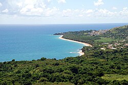
 The coastline of Maunabo | |
| Nicknames: "La Ciudad Tranquila", "Los Jueyeros", "Los Come Jueyes" | |
| Anthem: "Maunabo pueblito del sureste de mi amada patria Borinquén" | |
 Map of Puerto Rico highlighting Maunabo Municipality | |
| Coordinates: 18°00′25″N 65°53′57″W / 18.00694°N 65.89917°W | |
| Sovereign state | |
| Commonwealth | |
| Founded | March 9, 1799 |
| Founded by | Don Luis de Santiago |
| Barrios | |
| Government | |
| • Mayor | Ángel Omar Lafuente Amaro (PNP) |
| • Senatorial dist. | 7 - Humacao |
| • Representative dist. | 34 |
| Area | |
• Total | 27.88 sq mi (72.21 km2) |
| • Land | 21 sq mi (55 km2) |
| • Water | 6.64 sq mi (17.21 km2) |
| Population (2020)[1] | |
• Total | 10,589 |
| • Rank | 74th in Puerto Rico |
| • Density | 380/sq mi (150/km2) |
| Demonym | Maunabeños |
| Time zone | UTC−4 (AST) |
| ZIP Code | 00707 |
| Area code | 787/939 |
| Major routes | |
| Website | maunabomunicipio |
Maunabo (Spanish pronunciation: [mawˈnaβo]) is a town and municipality of Puerto Rico located in the Maunabo Valley on the southeastern coast, northeast of Patillas and south of Yabucoa. Maunabo is spread over eight barrios and Maunabo Pueblo (the downtown area and the administrative center of the city). It is part of the San Juan-Caguas-Guaynabo Metropolitan Statistical Area. The current mayor of the town is Ángel Omar Lafuente Amaro and the population in 2020 was 10,589.
- ^ "PUERTO RICO: 2020 Census". The United States Census Bureau. United States Census Bureau. Retrieved August 25, 2021.

