Back ماكدونو Arabic ماكدونو ARZ مک دنو، جورجیا AZB McDonough Catalan Макдоно (Джорджи) CE McDonough CEB McDonough, Georgia Welsh McDonough (Georgia) German McDonough Spanish McDonough (Georgia) Basque
McDonough, Georgia | |
|---|---|
City | |
 | |
| Nickname: The Geranium City | |
| Coordinates: 33°26′42″N 84°8′57″W / 33.44500°N 84.14917°W | |
| Country | |
| State | Georgia |
| County | Henry |
| Named for | Thomas Macdonough |
| Area | |
• Total | 13.01 sq mi (33.71 km2) |
| • Land | 12.85 sq mi (33.29 km2) |
| • Water | 0.16 sq mi (0.42 km2) |
| Elevation | 863 ft (263 m) |
| Population (2020) | |
• Total | 29,051 |
| • Density | 2,260.43/sq mi (872.72/km2) |
| Time zone | UTC-5 (Eastern (EST)) |
| • Summer (DST) | UTC-4 (EDT) |
| ZIP Codes | 30252–30253 |
| Area code(s) | 770/678/470 |
| FIPS code | 13-48624[2] |
| GNIS feature ID | 0317901[3] |
| Website | www |
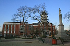
McDonough is a city in Henry County, Georgia, United States. It is part of the Atlanta metropolitan area. Its population was 29,051 in 2020. The city is the county seat of Henry County.[4] The unincorporated communities of Blacksville, Flippen, Kelleytown, and Ola are located near McDonough, and addresses in those communities have McDonough ZIP codes.
- ^ "2020 U.S. Gazetteer Files". United States Census Bureau. Retrieved December 18, 2021.
- ^ "U.S. Census website". United States Census Bureau. Retrieved January 31, 2008.
- ^ "US Board on Geographic Names". United States Geological Survey. October 25, 2007. Retrieved January 31, 2008.
- ^ "Find a County". National Association of Counties. Archived from the original on May 31, 2011. Retrieved June 7, 2011.


