Back مقاطعة ماكفرسون (نبراسكا) Arabic McPherson County, Nebraska BAR Макфиърсън (окръг, Небраска) Bulgarian ম্যাকফেরসন কাউন্টি, নেব্রাস্কা BPY McPherson Gông (Nebraska) CDO Макферсон (гуо, Небраска) CE McPherson County (kondado sa Tinipong Bansa, Nebraska) CEB McPherson County, Nebraska Welsh McPherson County (Nebraska) German Κομητεία Μακφέρσον (Νεμπράσκα) Greek
McPherson County | |
|---|---|
 McPherson County Courthouse in Tryon | |
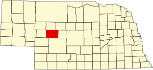
 Location within the U.S. state of Nebraska | |
 Nebraska's location within the U.S. | |
| Coordinates: 41°34′N 101°04′W / 41.57°N 101.06°W | |
| Country | |
| State | |
| Founded | 1890 |
| Named for | James B. McPherson |
| Seat | Tryon |
| Largest community | Tryon |
| Area | |
• Total | 860 sq mi (2,200 km2) |
| • Land | 859 sq mi (2,220 km2) |
| • Water | 1.0 sq mi (3 km2) 0.1% |
| Population (2020) | |
• Total | 399 |
| • Density | 0.46/sq mi (0.18/km2) |
| Time zone | UTC−6 (Central) |
| • Summer (DST) | UTC−5 (CDT) |
| Congressional district | 3rd |
| Website | www |
McPherson County is a county in the U.S. state of Nebraska. As of the 2020 Census, the population was 399,[1] making it the least populous county in the state of Nebraska and the fifth-least populous county in the United States. Its county seat is Tryon.[2] The county was formed in 1890 from Logan County; it was named for American Civil War General James B. McPherson.[3]
In 1913, a portion of McPherson County was partitioned off to create Arthur County, giving McPherson County its present boundaries.
McPherson County is part of the North Platte, NE Micropolitan Statistical Area.
In the Nebraska license plate system, McPherson County is represented by the prefix 90 (it ranked 90th of 93 counties in the number of vehicles registered when the license plate system was established in 1922).
- ^ "2020 Population and Housing State Data". The United States Census Bureau. United States Census Bureau. Retrieved August 15, 2021.
- ^ "Find a County". National Association of Counties. Retrieved June 7, 2011.
- ^ Gannett, Henry (1905). The Origin of Certain Place Names in the United States. Government Printing Office. p. 195.