Back ميلروس (نيومكسيكو) Arabic Melrose (Nou Mèxic) Catalan Melrose (lungsod sa Tinipong Bansa, New Mexico) CEB Melrose, New Mexico Welsh Melrose (Nuevo México) Spanish Melrose (Mexiko Berria) Basque ملروس، نیومکزیکو Persian Melrose (Nouveau-Mexique) French ملرؤز (نيۊمکزيکؤ) GLK Melrose, Novi Meksiko Croatian
Melrose | |
|---|---|
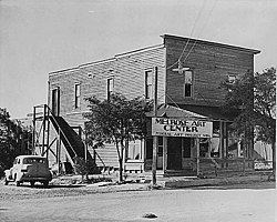
 Melrose Art Center in ca. 1935. It was run by Federal Art Project of Works Progress Administration. | |
 Location of Melrose, New Mexico | |
| Coordinates: 34°25′41″N 103°37′41″W / 34.42806°N 103.62806°W | |
| Country | United States |
| State | New Mexico |
| County | Curry |
| Area | |
• Total | 1.69 sq mi (4.38 km2) |
| • Land | 1.69 sq mi (4.38 km2) |
| • Water | 0.00 sq mi (0.00 km2) |
| Elevation | 4,406 ft (1,343 m) |
| Population | |
• Total | 622 |
| • Density | 368.05/sq mi (142.09/km2) |
| Time zone | UTC-7 (Mountain (MST)) |
| • Summer (DST) | UTC-6 (MDT) |
| ZIP code | 88124 |
| Area code | 575 |
| FIPS code | 35-47570 |
| GNIS feature ID | 2413572[2] |
Melrose is a village in Curry County, New Mexico, United States. Its population was 622 at the 2020 census.[4] The town is losing population due to rural exodus.
- ^ "ArcGIS REST Services Directory". United States Census Bureau. Retrieved October 12, 2022.
- ^ a b U.S. Geological Survey Geographic Names Information System: Melrose, New Mexico
- ^ Cite error: The named reference
USCensusDecennial2020CenPopScriptOnlywas invoked but never defined (see the help page). - ^ "Explore Census Data". data.census.gov. Retrieved February 3, 2025.
