Back ميوار Arabic Mewar German Mewar French मेवाड़ Hindi Mewar ID Mewar Italian メーワール Japanese 메와르 Korean मेवाड़ MAI മേവാർ Malayalam
Mewar | |
|---|---|
 | |
| Country | |
| Area | |
• Total | 33,517 km2 (12,941 sq mi) |
| Population (2011[citation needed]) | |
• Total | 9,045,726 |
| • Density | 270/km2 (700/sq mi) |
| Languages | |
| • Major languages | Mewari, Hindi |
| Time zone | UTC+05:30 (IST) |
| ISO 3166 code | IN-MP |
| Largest city | Udaipur |
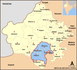
Mewar, also spelled as Mewad is a region in the south-central part of Rajasthan state of India. It includes the present-day districts of Bhilwara, Chittorgarh, Pratapgarh, Rajsamand, Udaipur, Pirawa Tehsil of Jhalawar District of Rajasthan, Neemuch and Mandsaur of Madhya Pradesh and some parts of Gujarat.
For centuries, the region was ruled by Rajputs as Kingdom of Mewar. During the period of British East India Company, it became a princely state as Udaipur. It emerged as an administrative unit during the period governance in India and remained until the end of the British Raj era.
The Mewar region lies between the Aravali Range to the northwest, Ajmer to the north, Gujarat and the Vagad region of Rajasthan to the south, the Malwa region of Madhya Pradesh state to the south and the Hadoti region of Rajasthan to the east.