Back ميري (ماليزيا) Arabic Мири Bulgarian Miri (lungsod) CEB Miri German Μίρι (Μαλαισία) Greek Miri Esperanto Miri Spanish میری (مالزی) Persian Miri Finnish Miri French
Miri | |
|---|---|
City and district capital | |
| City of Miri Bandaraya Miri | |
| Other transcription(s) | |
| • Jawi | ميري |
| • Chinese | 美里 Měilǐ (Hanyu Pinyin) |
From top, left to right: Miri City lookout from Canada Hill, the old Miri City Council Complex, Miri World War 2 Memorial Park, the Iconic Seahorse Lighthouse, and Miri Petroleum Museum. | |
| Nickname(s): "Resort City" (Bandaraya Peranginan), "Oil Town" (Bandar Minyak) | |
| Motto: Maju Bersama Masyarakat (English: Progress with the Society) | |
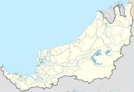
 Location of Miri in Sarawak | |
| Coordinates: 04°23′33″N 113°59′10″E / 4.39250°N 113.98611°E | |
| Country | |
| State | |
| Division | Miri |
| District | Miri |
| Founded by Royal Dutch Shell | 10 August 1910 |
| Granted municipality status | 6 November 1981 |
| Granted city status | 20 May 2005 |
| Government | |
| • Type | City council |
| • Body | Miri City Council |
| • Mayor | Adam Yii Siew Sang |
| Area | |
• Miri City | 997.43 km2 (385.11 sq mi) |
| Elevation | 8 m (26 ft) |
| Lowest elevation | 0 m (0 ft) |
| Population (2022)[5] | |
• Miri City | 248,877 (as per administrative district) |
| • Demonym | Mirian |
| Time zone | UTC+08:00 (MST) |
| • Summer (DST) | UTC+08:00 (Not observed) |
| Postal code | 98xxx |
| Area code(s) | +6085 (landline only) |
| Vehicle registration | QM and QM****A (etc..) (for all vehicles except taxis) HQ (for taxis only) |
| Website | www |
Miri (/ˈmɪri/; Jawi: ميري; Chinese: 美里; pinyin: Měilǐ) is a coastal city in north-eastern Sarawak, Malaysia, located near the border of Brunei, on the island of Borneo. The city covers an area of 997.43 square kilometres (385.11 sq mi),[2] located 798 kilometres (496 mi) northeast of Kuching[6] and 329 kilometres (204 mi) southwest of Kota Kinabalu.[7] Miri is the second largest city in Sarawak,[8] with a population of 356,900 as of 2020.[5] The city is also the capital of Miri District, Miri Division.
Before Miri was founded, Marudi was the administrative centre of the northern region of Sarawak. Miri was founded in 1910 when the first oil well was drilled by Royal Dutch Shell. The discovery of an oil field in Miri has led to rapid development of Miri town. Miri became the administrative centre of the northern region of Sarawak by 1929. During World War II, the Miri oil fields were destroyed by the Brooke government to sabotage Japanese operations in Southeast Asia but to no avail; Miri town was the first landing point of Japanese troops in Borneo. The subsequent Japanese occupation led Miri to become a target of Allied air raids which caused the destruction of oil refinery facilities in Miri. The petroleum industry continued to be a major player in the city's economy after the war. Oil exploration has moved offshore since the 1950s, but subsequently new inland oil fields were found in 1989 and 2011. In 1974, the formation of Malaysian oil and gas company Petronas led to co-operation between Petronas and Shell on oil exploration in the Miri region. In 2005, Miri became the 10th city in Malaysia to be granted official city status, the first non-state-capital city to be bestowed such status.
Miri is the main tourist gateway to the world-famous UNESCO World Heritage Site, Gunung Mulu National Park; Loagan Bunut National Park; Lambir Hills National Park; and Niah National Park and Miri-Sibuti Coral Reef National Park.[9][10] The Gunung Mulu National Park with its Sarawak Chamber, which is the largest known cave chamber in the world by area, remains one of the favourite ecotourism destinations in Miri.[8] Miri is also the birthplace of the Malaysian petroleum industry. Other major industries in the city include timber, oil palm and tourism.
- ^ "Official Website of Miri City Council - Mayor message". Miri City Council. Retrieved 19 March 2015.
- ^ a b "Miri Council ... in Brief". Website of Miri City Council. Website of Miri City Council. 4 September 2014. Retrieved 7 September 2014.
- ^ "Miri, Malaysia Weather History and Climate Data". World Climate. Archived from the original on 7 January 2004. Retrieved 21 March 2015.
- ^ "Malaysia Elevation Map (Elevation of Miri)". Flood Map : Water Level Elevation Map. Archived from the original on 22 August 2015. Retrieved 22 August 2015.
- ^ "Miri, Sarawak to Kuching, Sarawak". Google Maps. Archived from the original on 21 March 2015. Retrieved 21 March 2015.
- ^ "Miri, Sarawak to Kota Kinabalu, Sabah". Google Maps. Archived from the original on 21 March 2015. Retrieved 21 March 2015.
- ^ a b Sarawak Visitors' Guide 2014 - Miri (PDF). Sarawak: Sarawak Tourism Board. 2014. pp. 73, 78. Archived from the original on 21 March 2015.
- ^ "Diving in Miri-Sibuti Coral Reefs National Park". Sarawak Tourism Board. Archived from the original on 21 March 2015. Retrieved 21 March 2015.
- ^ "Miri Nature Society: Coral reefs in Miri under threat". The Borneo Post. 21 June 2010. Archived from the original on 22 February 2014. Retrieved 21 March 2015.


