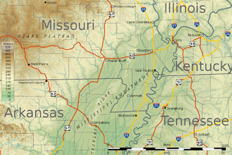
Missouri Bootheel | |
|---|---|
 Location of the bootheel region centered on 36°15′N 89°51′W / 36.250°N 89.850°W | |
| Area | |
| • Land | 1,708.45 sq mi (4,424.9 km2) |
| Population (2019)[2] | |
• Total | 62,012 |
| • Density | 36.3/sq mi (14.0/km2) |

The Missouri Bootheel is a salient (protrusion) located in the southeasternmost part of the U.S. state of Missouri, extending south of 36°30′ north latitude, so called because its shape in relation to the rest of the state resembles the heel of a boot. Strictly speaking, it is composed of some or all of the counties of Dunklin, New Madrid, and Pemiscot. However, the term is locally used to refer to the entire southeastern lowlands of Missouri located within the Mississippi Embayment, which includes parts of Butler, Mississippi, Ripley, Scott, Stoddard and extreme southern portions of Cape Girardeau and Bollinger counties. The largest city in the region is Kennett.
Until the 1920s, the district was a wheat-growing area of family farms. Following the invasion of the boll weevil, which ruined the cotton crop in Arkansas, planters moved in. They bought up the land for conversion to cotton commodity crops, bringing along thousands of sharecroppers.[3] After mechanization of agriculture and other changes in the 1930s, many black families left the area to go north in the Great Migration. These counties have predominantly white populations in the 21st century, although some have a significant number of black residents.
- ^ "United States Summary: 2010, Population and Housing Unit Counts, 2010 Census of Population and Housing" (PDF). United States Census Bureau. September 2012. pp. V–2, 1 & 41 (Tables 1 & 18). Retrieved February 7, 2014.
- ^ "Population, Population Change, and Estimated Components of Population Change: April 1, 2010 to July 1, 2019 (NST-EST2019-alldata)". Census.gov. United States Census Bureau. Archived from the original on January 26, 2020. Retrieved February 8, 2020.
- ^ Peirce, Neal R.; Hagstrom, Jerry (1983). The Book of America: Inside the Fifty States Today. New York: Norton. p. 594. ISBN 0-393-01639-0.
