Back مونموث (ويلز) Arabic Trefynwy AST Монмут Bashkir Монмут (Монмутшыр) Byelorussian Монмът Bulgarian Menoe (kêr) Breton Monmouth (Gal·les) Catalan Monmouth (lungsod sa Hiniusang Gingharian, Wales, Monmouthshire, lat 51,81, long -2,71) CEB Monmouth Czech Trefynwy Welsh
Monmouth
| |
|---|---|
 | |
 Flag | |
Location within Monmouthshire | |
| Population | 10,508 (2011)[1] |
| OS grid reference | SO505125 |
| Principal area | |
| Preserved county | |
| Country | Wales |
| Sovereign state | United Kingdom |
| Post town | MONMOUTH |
| Postcode district | NP25 |
| Dialling code | 01600 |
| Police | Gwent |
| Fire | South Wales |
| Ambulance | Welsh |
| UK Parliament | |
| Senedd Cymru – Welsh Parliament | |
| Website | www.monmouth.gov.uk |
Monmouth (/ˈmɒnməθ/ MON-məth or /ˈmʌn-/ MUN-; Welsh: Trefynwy, lit. 'Town on the Monnow') is a market town and community in Monmouthshire, Wales, situated on where the River Monnow joins the River Wye, two miles (three kilometres) from the Wales–England border. The population in the 2011 census was 10,508, rising from 8,877 in 2001. Monmouth was the county town of historic Monmouthshire, although Abergavenny is the largest settlement and Monmouthshire County Council has its main offices at Rhadyr, just outside Usk. Monmouth is in the UK Parliament constituency of Monmouthshire and the Senedd constituency of Monmouth.
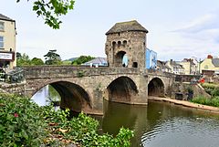
The town was the site of a small Roman fort, Blestium, and became established after the Normans built Monmouth Castle c. 1067. The medieval stone gated bridge is the only one of its type remaining in Britain. The castle later came into the possession of the House of Lancaster, and was the birthplace of King Henry V in 1386.
- ^ "Town population 2011". Archived from the original on 7 April 2015. Retrieved 3 April 2015.

