Back مقاطعة مونتغومري (بنسيلفانيا) Arabic Montgomery County, Pennsylvania BAR Монтгомъри (окръг, Пенсилвания) Bulgarian মন্টগোমেরী কাউন্টি, পেনসিলভানিয়া BPY Montgomery Gông (Pennsylvania) CDO Montgomery County (kondado sa Tinipong Bansa, Pennsylvania) CEB Montgomery County, Pennsylvania Welsh Montgomery County (Pennsylvania) German Κομητεία Μοντγκόμερι (Πενσυλβάνια) Greek Kantono Montgomery (Pensilvanio) Esperanto
Montgomery County | |
|---|---|
 Montgomery County Courthouse in Norristown, May 2007 | |
| Nickname: Montco[1] | |
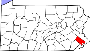
 Location within the U.S. state of Pennsylvania | |
 Pennsylvania's location within the U.S. | |
| Coordinates: 40°13′N 75°22′W / 40.21°N 75.37°W | |
| Country | |
| State | |
| Founded | September 10, 1784 |
| Named for | Richard Montgomery or Montgomeryshire |
| Seat | Norristown |
| Largest municipality | Lower Merion Township |
| Government | |
| • County Commissioners | Jamila H. Winder, Chair Neil K. Makhija, Vice Chair Thomas DiBello, Commissioner |
| Area | |
• Total | 487 sq mi (1,260 km2) |
| • Land | 483 sq mi (1,250 km2) |
| • Water | 4.2 sq mi (11 km2) 0.9% |
| Population (2020) | |
• Total | 856,553 |
• Estimate (2022) | 868,742 |
| • Density | 1,773/sq mi (685/km2) |
| Time zone | UTC−5 (Eastern) |
| • Summer (DST) | UTC−4 (EDT) |
| Congressional districts | 1st, 4th, 5th |
| Website | montgomerycountypa.gov |
Montgomery County, colloquially referred to as Montco,[1] is a county in the Commonwealth of Pennsylvania. As of the 2020 census, the population of the county was 856,553, making it the third-most populous county in Pennsylvania after Philadelphia and Allegheny counties, also the most populous county in Pennsylvania without a major city.[2] The county is part of the Southeast Pennsylvania region of the state.[a]
The county seat and largest city is Norristown.[3] The county is part of the Philadelphia–Camden–Wilmington PA-NJ–DE–MD metropolitan statistical area, known as the Delaware Valley, and marks the Delaware Valley's northern border with the Lehigh Valley region of eastern Pennsylvania.
The county borders Philadelphia, the nation's sixth-largest city, to its southeast, Bucks County to its east, Berks and Lehigh counties to its north, Delaware County to its south, and Chester County to its southwest.
The county was created on September 10, 1784, out of land originally part of Philadelphia County. The first courthouse was housed in the Barley Sheaf Inn. It is believed to have been named either for Richard Montgomery, an American Revolutionary War general killed in 1775 while attempting to capture Quebec City, or for the Welsh county of Montgomeryshire, which was named after one of William the Conqueror's main counselors, Roger de Montgomerie, since it was part of the Welsh Tract, an area of Pennsylvania settled by Quakers from Wales.[4]
- ^ a b
- "Amos Lee Performs, Montco Train Derailment, The First Lady of World War II". WHYY. Retrieved July 20, 2023.
- "NEXT Weather: Tornado warnings expire for Philadelphia, MontCo". CBS News Philadelphia. July 16, 2023. Retrieved July 20, 2023.
- Stamm, Dan (July 18, 2023). "Pa. Turnpike in Montco was closed for hours Tuesday morning". NBC10 Philadelphia. Retrieved July 20, 2023.
- ^ "State & County QuickFacts". United States Census Bureau. Retrieved July 5, 2022.
- ^ "Find a County". National Association of Counties. Archived from the original on May 31, 2011. Retrieved June 7, 2011.
- ^ "Montgomery County, Pennsylvania". Family Search. Retrieved January 21, 2015.
Cite error: There are <ref group=lower-alpha> tags or {{efn}} templates on this page, but the references will not show without a {{reflist|group=lower-alpha}} template or {{notelist}} template (see the help page).


