Back مقاطعة مونتغومري (تكساس) Arabic Montgomery County, Texas BAR Мантгомеры (акруга, Тэхас) Byelorussian Монтгомъри (окръг, Тексас) Bulgarian মন্টগোমেরী কাউন্টি, টেক্সাস BPY Montgomery Gông (Texas) CDO Montgomery County (kondado sa Tinipong Bansa, Texas) CEB Montgomery County (Texas) Czech Montgomery County, Texas Welsh Montgomery County (Texas) German
Montgomery County | |
|---|---|
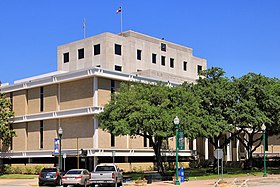
 The Montgomery County Courthouse in Conroe | |
 Location within the U.S. state of Texas | |
 Texas's location within the U.S. | |
| Coordinates: 30°18′N 95°30′W / 30.3°N 95.5°W | |
| Country | |
| State | |
| Founded | 1837 |
| Named for | Montgomery, Texas |
| Seat | Conroe |
| Largest community | The Woodlands |
| Area | |
• Total | 1,077 sq mi (2,790 km2) |
| • Land | 1,042 sq mi (2,700 km2) |
| • Water | 35 sq mi (90 km2) 3.3% |
| Population (2020) | |
• Total | 620,443 |
• Estimate (2023) | 711,354 |
| • Density | 580/sq mi (220/km2) |
| Time zone | UTC−6 (Central) |
| • Summer (DST) | UTC−5 (CDT) |
| Congressional districts | 2nd, 8th |
| Website | www |
Montgomery County is a county in the U.S. state of Texas. As of the 2020 U.S. census, the county had a population of 620,443.[1] The county seat is Conroe.[2] The county was created by an act of the Congress of the Republic of Texas on December 14, 1837, and is named for the town of Montgomery.[3] Between 2000 and 2010, its population grew by 55%, the 24th-fastest rate of growth of any county in the United States. Between 2010 and 2020, its population grew by 36%. According to the U.S. Census Bureau, the estimated population is 711,354 as of July 1, 2023.
Montgomery County is part of the Houston–The Woodlands–Sugar Land metropolitan statistical area.
- ^ "U.S. Census website". United States Census Bureau. Retrieved December 13, 2021.
- ^ "Find a County". National Association of Counties. Retrieved June 7, 2011.
- ^ Searle, Kameron K. The Early History of Montgomery, Texas. City of Montgomery, Texas: July 7, 2012. Accessed on June 5, 2021.