Back মোসভিক BPY Mosvik Danish Mosvik German Mosvik Spanish Mosvik Basque Mosvik Finnish Mosvik French Mosvik Italian Mosvik JV Mosvik LI
Mosvik Municipality
Mosvik kommune | |
|---|---|
| Mosviken herred (historic name) | |
 View of Mosvik village | |
 Nord-Trøndelag within Norway | |
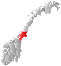
 Mosvik within Nord-Trøndelag | |
| Coordinates: 63°49′13″N 11°00′24″E / 63.8203°N 11.0066°E | |
| Country | Norway |
| County | Nord-Trøndelag |
| District | Innherred |
| Established | 1 Jan 1901 |
| • Preceded by | Mosvik og Verran Municipality |
| Disestablished | 1 Jan 2012 |
| • Succeeded by | Inderøy Municipality |
| Administrative centre | Mosvik |
| Government | |
| • Mayor (2003–2011) | Carl Ivar von Køppen (Sp) |
| Area (upon dissolution) | |
• Total | 219.37 km2 (84.70 sq mi) |
| • Land | 205.57 km2 (79.37 sq mi) |
| • Water | 13.80 km2 (5.33 sq mi) 6.3% |
| • Rank | #320 in Norway |
| Highest elevation | 502.45 m (1,648.46 ft) |
| Population (2011) | |
• Total | 811 |
| • Rank | #417 in Norway |
| • Density | 3.7/km2 (10/sq mi) |
| • Change (10 years) | |
| Demonym | Mosbygg[2] |
| Official language | |
| • Norwegian form | Bokmål |
| Time zone | UTC+01:00 (CET) |
| • Summer (DST) | UTC+02:00 (CEST) |
| ISO 3166 code | NO-1723[4] |
Mosvik is a former municipality in the old Nord-Trøndelag county in Norway. The municipality was part of the Innherred region. The 219.37-square-kilometre (84.70 sq mi) municipality existed from 1901 until its dissolution in 2012. The old municipality encompassed the southern part of what is now Inderøy Municipality in Trøndelag county. The municipality was located along the western shore of the Trondheimsfjorden and on the southwestern end of the Beitstadfjorden. The administrative centre of the municipality was the village of Mosvik where Mosvik Church is located. Other villages located near the village of Mosvik include Trongsundet, Framverran, Venneshamn, and Kjerringvik.[5]
Prior to its dissolution in 2012, the 219-square-kilometre (85 sq mi) municipality was the 320th largest by area out of the 430 municipalities in Norway. Mosvik Municipality was the th most populous municipality in Norway with a population of about 811. The municipality's population density was 3.7 inhabitants per square kilometre (9.6/sq mi) and its population had decreased by 12.9% over the previous 10-year period.[6][7]
Until 1991, the connection from Mosvik Municipality to the rest of the Innherred region was only available by a car ferry, at first via Ytterøya to Levanger, but later directly to Inderøy Municipality on the Vangshylla–Kjerringvik Ferry route. In 1991, the Skarnsund Bridge on Norwegian County Road 755 was completed, eliminating the need for a ferry across the Skarnsundet strait.[5] The Skarnsund bridge was opened by King Harald V on 19 December 1991, after he had taken the last ferry across the fjord. A monument, the King's Stone, bearing the signature of the king, is located at the resting place on the Mosvik side.
Mosvik features two of Norway's 23 tallest structures: the Skavlen transmitter television and radio transmitter at 165 metres (541 ft) and the Skarnsund Bridge at 152 metres (499 ft).
- ^ "Høgaste fjelltopp i kvar kommune" (in Norwegian). Kartverket. 16 January 2024.
- ^ "Navn på steder og personer: Innbyggjarnamn" (in Norwegian). Språkrådet.
- ^ "Forskrift om målvedtak i kommunar og fylkeskommunar" (in Norwegian). Lovdata.no.
- ^ Bolstad, Erik; Thorsnæs, Geir, eds. (9 January 2024). "Kommunenummer". Store norske leksikon (in Norwegian). Foreningen Store norske leksikon.
- ^ a b Olsen Haugen, Morten, ed. (19 October 2017). "Mosvik". Store norske leksikon (in Norwegian). Kunnskapsforlaget. Retrieved 11 April 2018.
- ^ Statistisk sentralbyrå. "Table: 06913: Population 1 January and population changes during the calendar year (M)" (in Norwegian).
- ^ Statistisk sentralbyrå. "09280: Area of land and fresh water (km²) (M)" (in Norwegian).

