Back Маунт-Гамбиер Abkhazian مونت غامبير Arabic مونت جامبير ARZ مونت قامبیر، گونئی اوسترالیا AZB Mount Gambier (lungsod) CEB ماونت گەمبیێر CKB Mount Gambier Welsh Mount Gambier German Mount Gambier Spanish Mount Gambier Estonian
| Mount Gambier South Australia | |||||||||||||||
|---|---|---|---|---|---|---|---|---|---|---|---|---|---|---|---|
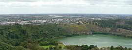
 View north across Valley Lake and Marist Park to the eastern urban area of Mount Gambier from Centenary Tower | |||||||||||||||
| Coordinates | 37°49′46″S 140°46′58″E / 37.82944°S 140.78278°E | ||||||||||||||
| Population | 26,734 (UCL 2021)[1] | ||||||||||||||
| Established | 1854 | ||||||||||||||
| Postcode(s) | 5290,[2] 5291[3] | ||||||||||||||
| Area | 193.3 km2 (74.6 sq mi)[4] (2011 urban) | ||||||||||||||
| Time zone | ACST (UTC+9:30) | ||||||||||||||
| • Summer (DST) | ACDT (UTC+10:30) | ||||||||||||||
| Location | |||||||||||||||
| LGA(s) | |||||||||||||||
| County | Grey | ||||||||||||||
| State electorate(s) | Mount Gambier | ||||||||||||||
| Federal division(s) | Barker | ||||||||||||||
| |||||||||||||||
| |||||||||||||||
Mount Gambier is the second most populated city in South Australia, with an estimated urban population of 26,878 as of 2021[update]. The city is located on the slopes of Mount Gambier, a volcano in the south east of the state, about 450 kilometres (280 mi) south-east of the capital Adelaide and just 17 kilometres (11 mi) from the Victorian border. The traditional owners of the area are the Bungandidj (or Buandik) people. Mount Gambier is the most important settlement in the Limestone Coast region and the seat of government for both the City of Mount Gambier and the District Council of Grant.
The city is well known for its geographical features, particularly its volcanic and limestone features, most notably Blue Lake /Waawor /Warwar, and its parks, gardens, caves and sinkholes.
- ^ Australian Bureau of Statistics (28 June 2022). "Mount Gambier (urban centre and locality)". Australian Census 2021.
- ^ Australia Post[permanent dead link] – Postcode: Mount Gambier, SA (25 June 2008)
- ^ Australia Post Archived 11 January 2022 at the Wayback Machine – Postcode: Mount Gambier West, Mount Gambier East, SA (25 June 2008)
- ^ "2011 Census Community Profiles: Mount Gambier". ABS Census. Australian Bureau of Statistics. Archived from the original on 8 March 2014. Retrieved 15 September 2016.
