Back Mount Mansfield Afrikaans جبل مونت مانسفيلد ARZ Mount Mansfield BAR Mount Mansfield (bukid sa Tinipong Bansa) CEB Mount Mansfield German کوه منسفیلد Persian Mont Mansfield French マンスフィールド山 Japanese Mount Mansfield LLD Mansfildo kalnas Lithuanian
| Mount Mansfield | |
|---|---|
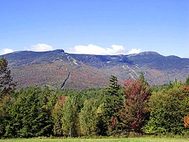
 Mount Mansfield, September 2004 | |
| Highest point | |
| Elevation | 4,395 ft (1,340 m) NAVD 88[1] |
| Prominence | 3,633 ft (1,107 m)[2] |
| Listing | U.S. state high point 26th New England Fifty Finest 3rd New England 4000-footers |
| Coordinates | 44°32′38″N 72°48′52″W / 44.543946911°N 72.814309717°W[1] |
| Geography | |
| Parent range | Green Mountains |
| Topo map | USGS Mount Mansfield |
| Climbing | |
| Easiest route | Hike |
| Designated | 1980 |
Mount Mansfield is the highest mountain in Vermont, reaching an elevation of 4,393 feet (1,339 m) above sea level.[3] Located in the northwest of the state, it is also the highest peak in the Green Mountains. Its summit is located within the town of Underhill in Chittenden County; the ridgeline, including some secondary peaks, extends into the town of Stowe in Lamoille County, and the mountain's flanks also reach into the town of Cambridge.[4]
When viewed from the east or west, this mountain has the appearance of a (quite elongated) human profile, with distinct forehead, nose, lips, chin, and Adam's apple. These features are most distinct when viewed from the east; unlike most human faces, the chin is the highest point.[5]
Mount Mansfield is one of three spots in Vermont where true alpine tundra survives from the Ice Ages. A few acres exist on Camel's Hump and Mount Abraham nearby and to the south, but Mount Mansfield's summit still holds about 200 acres (81 ha). In 1980, the Mount Mansfield Natural Area was designated as a National Natural Landmark by the National Park Service.[6]
Located in Mount Mansfield State Forest, the mountain is used for various recreational and commercial purposes. "The Nose" is home to transmitter towers for a number of regional radio and TV stations.[7][8] There are many hiking trails, including the Long Trail, which traverses the main ridgeline. In addition, the east flank of the mountain is used by the Stowe Mountain Resort for winter skiing. A popular tourist activity is to drive[9] the 4.5-mile (7.2 km) toll road (a steep, mostly unpaved road with several hairpin turns) from the Stowe Base Lodge to "The Nose" and then hike along the ridge to "The Chin."
- ^ a b "Mt Mansfield Highest Point". NGS Data Sheet. National Geodetic Survey, National Oceanic and Atmospheric Administration, United States Department of Commerce. Retrieved December 11, 2008.
- ^ "Mount Mansfield, Vermont". Peakbagger.com. Retrieved December 15, 2008.
- ^ Conway, Michael J. Vieira & J. North (April 10, 2017). New England Rocks: Historic Geological Wonders. Arcadia Publishing. ISBN 978-1-4396-6034-8.
- ^ Vermont Atlas & Gazetteer, Delorme, 1996, p. 46.
- ^ Robert L. Hagerman, Mansfield: The Story of Vermont's Loftiest Mountain. Essex Publishing Co., Essex Junction, Vt., 1971, pp. 23-24.
- ^ "National Natural Landmarks - National Natural Landmarks (U.S. National Park Service)". www.nps.gov. Retrieved April 12, 2019.
Year designated: 1980
- ^ Radio stations in Burlington, VT (see info under Mount Mansfield with photos on bottom of the page), worldradiomap.com
- ^ Engineering Radio/TV Mount Mansfield
- ^ waitingroom.snow.com https://waitingroom.snow.com/?c=vailresorts&e=vailresortsecomm1&ver=v3-aspnet-3.6.2&cver=138&man=Sapphire%20-%20All%20Non%20Reservation%20Pages%20and%20APIs%20-%20PROD&t=https%3A%2F%2Fwww.stowe.com%2Fexplore-the-resort%2Factivities-and-events%2Fauto-toll-road.aspx. Retrieved September 3, 2024.
{{cite web}}: Missing or empty|title=(help)
