Back جبل مونت اوسا ARZ Mount Ossa (bukid sa Ostralya, State of Tasmania, Meander Valley) CEB Mount Ossa Czech Mount Ossa German Montaña Ossa Spanish Mount Ossa (Tasmania) Finnish Mont Ossa (Tasmanie) French Monte Ossa (Tasmania) Italian オッサ山 (タスマニア) Japanese ოსა (მთა) Georgian
| Mount Ossa | |
|---|---|
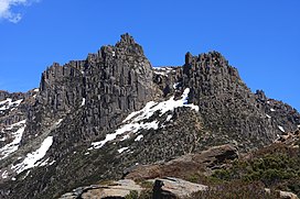
 Mount Ossa pictured in 2009 | |
| Highest point | |
| Elevation | 1,617 m (5,305 ft)[1] |
| Prominence | 1,617 m (5,305 ft)[1] |
| Isolation | 524 km (326 mi)[1] |
| Listing | Ultra[1] State high point |
| Coordinates | 41°52′12″S 146°01′48″E / 41.87000°S 146.03000°E[2] |
| Geography | |
Location in Tasmania | |
| Location | Central Highlands of Tasmania, Australia |
| Parent range | Pelion Range |
| Geology | |
| Rock age | Jurassic |
| Mountain type | Dolerite |
| Climbing | |
| Easiest route | 3+1⁄2 hour return from Pelion Gap via the Overland Track |
Mount Ossa is the highest mountain in Tasmania, with a summit elevation of 1,617 metres (5,305 ft) above sea level.[3] It makes up part of the Pelion Range within Cradle Mountain-Lake St Clair National Park in the Central Highlands region of Tasmania, Australia.
It was first surveyed by Europeans in the 1860s, and confirmed to be the state's high point in 1954.
Like most peaks in the area it is capped with Jurassic dolerite.[4]
- ^ a b c d "Mount Ossa, Australia". Peakbagger.com. Retrieved 2 February 2014.
- ^ "Mount Ossa". Gazetteer of Australia online. Geoscience Australia, Australian Government.
- ^ "LISTmap (Mount Ossa)". Tasmanian Government Department of Primary Industries and Water. Retrieved 19 June 2007.
- ^ I.B. Jennings. "Geology of the Cradle Mountain Reserve" (PDF). Economic and General Geology.
