Back إقليم متوارا Arabic TanzaniaMtwaraGola AVK Мтвара (регион) Bulgarian Regió de Mtwara Catalan Mtwara Region CEB Mtwara (region) Danish Mtwara (Region) German Περιφέρεια Μτουάρα Greek Regiono Mtwara Esperanto Región de Mtwara Spanish
Mtwara Region (Konde)
Mkoa wa Mtwara (Swahili) | |
|---|---|
|
From top to bottom: Bird's eye view of Mikindani Bay, Swahili Door in Mtwara and historic Mikindani | |
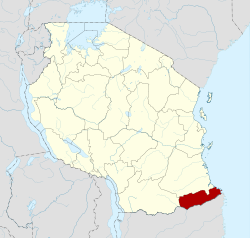
 Mtwara Region in Tanzania | |
| Coordinates: 10°38′30.12″S 39°14′15.36″E / 10.6417000°S 39.2376000°E | |
| Country | |
| Zone | Coastal |
| Administrative Region | 1971 |
| Named for | The port of Mtwara |
| Capital | Mtwara |
| Districts | |
| Government | |
| • Regional Commissioner | Ahmed Abbas Ahmed |
| Area | |
• Total | 16,710 km2 (6,450 sq mi) |
| • Rank | 23rd of 31 |
| Highest elevation (Masasi Hill) | 837 m (2,746 ft) |
| Population (2022) | |
• Total | 1,634,947 |
| • Rank | 20th of 31 |
| • Density | 98/km2 (250/sq mi) |
| Demonym | Mtwaran |
| Ethnic groups | |
| • Settler | Swahili |
| • Native | Makonde |
| Time zone | UTC+3 (EAT) |
| Postcode | 21xxx |
| Area code | 023 |
| ISO 3166 code | TZ-17 |
| HDI (2018) | 0.507[1] low· 22nd of 25 |
| Website | Official website |
| Symbols of Tanzania | |
| Bird |  |
| Butterfly | |
| Fish | |
| Mammal | |
| Tree |  |
| Mineral |  |
Mtwara Region (Mkoa wa Mtwara in Swahili) is one of Tanzania's 31 administrative regions, with its capital as the municipality of Mtwara. Mtwara Region is home to one of the most infuluential people in Tanzania, the Makonde. Mtwara is home to Tanzania's 4th president Benjamin Mkapa and is home to a number of influential artists. The boundary with Mozambique to the south is formed by the Ruvuma River. To the west, Mtwara is bordered by Ruvuma Region, to the north by Lindi Region, and to the east is the Indian Ocean.
Mtwara Region is home for being the nation's largest producer of Cashew nuts. According to the 2012 national census, the region had a population of 1,270,854, which was lower than the pre-census projection of 1,374,767.[2]: page 2 For 2002-2012, the region's 1.2 percent average annual population growth rate was the 26th highest in the country.[2]: page 4 It was also the fourteenth most densely populated region with 76 people per square kilometer.[2]: page 6
- ^ "Sub-national HDI - Area Database - Global Data Lab". hdi.globaldatalab.org. Archived from the original on 2018-09-23. Retrieved 2020-02-26.
- ^ a b c Population Distribution by Administrative Units, United Republic of Tanzania, 2013 Archived 2013-05-02 at the Wayback Machine


