Back نابير فيلد Arabic نابير فيلد ARZ ناپیر فیلد، آلاباما AZB Napier Field (Alabama) Catalan Напьэр-Филд CE Napier Field CEB نەیپیەر فیڵد، ئەلاباما CKB Napier Field, Alabama Welsh Napier Field Spanish Napier Field (Alabama) Basque
Napier Field, Alabama | |
|---|---|
 Napier Field, Alabama | |
 Location of Napier Field in Dale County, Alabama. | |
| Coordinates: 31°18′55″N 85°27′16″W / 31.31528°N 85.45444°W | |
| Country | United States |
| State | Alabama |
| County | Dale |
| Area | |
• Total | 0.26 sq mi (0.66 km2) |
| • Land | 0.26 sq mi (0.66 km2) |
| • Water | 0.00 sq mi (0.00 km2) |
| Elevation | 374 ft (114 m) |
| Population (2020) | |
• Total | 409 |
| • Density | 1,597.66/sq mi (617.36/km2) |
| Time zone | UTC-6 (Central (CST)) |
| • Summer (DST) | UTC-5 (CDT) |
| FIPS code | 01-53256 |
| GNIS feature ID | 0123635 |
| Website | http://www.napierfield.com |
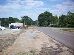
Napier Field is a town in Dale County, Alabama. At the 2020 census, the population was 409. It is part of the Ozark micropolitan statistical area. The town was originally constructed as a military air base during the Second World War. It is currently adjacent to Dothan Regional Airport. While the airport itself lies within Dothan's city limits, the adjacent housing units and other buildings constitute the incorporated town of Napier Field.
- ^ "2020 U.S. Gazetteer Files". United States Census Bureau. Retrieved October 29, 2021.
