Back Narmada Afrikaans نهر نرمادة Arabic نهر نارمادا ARZ نرمدا چایی AZB Нармада Byelorussian Нармада (река) Bulgarian नर्मदा नदी Bihari নর্মদা নদী Bengali/Bangla Narmada Breton Narmada Catalan
| Narmada | |
|---|---|
 At Bhedaghat in Jabalpur, India | |
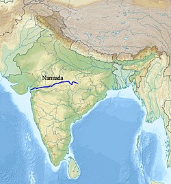
  Maps showing the course of the Narmada, selected tributaries, and the approximate extent of its drainage area | |
| Location | |
| Country | India |
| State | Madhya Pradesh, Maharashtra, Gujarat |
| City | Narmadapuram, Budhni, Jabalpur, Dindori, Narsinghpur Harda, Mandhata, Omkareshwar, Barwaha, Mandleshwar, Maheshwar, Barwani, Mandla, Bharuch, Rajpipla, Sinor (Vadodara District), Dabhoi (Vadodara District), Karjan (Vadodara District), Dharampuri |
| Physical characteristics | |
| Source | Narmada Kund |
| • location | Vindhyachal Parvat Amarkantak Plateau, Anuppur district, Central India, Madhya Pradesh |
| • coordinates | 22°40′0″N 81°45′0″E / 22.66667°N 81.75000°E |
| • elevation | 1,048 m (3,438 ft) |
| Mouth | Gulf of Khambhat (Arabian Sea) |
• location | Bharuch District, Gujarat |
• coordinates | 21°39′4″N 72°48′43″E / 21.65111°N 72.81194°E |
• elevation | 0 m (0 ft) |
| Length | 1,312 km (815 mi)approx. |
| Discharge | |
| • average | 1,447 m3/s (51,100 cu ft/s) |
| Discharge | |
| • location | Garudeshwar[1] |
| • average | 1,216 m3/s (42,900 cu ft/s) |
| • minimum | 10 m3/s (350 cu ft/s) |
| • maximum | 11,246 m3/s (397,100 cu ft/s) |
| Basin features | |
| Tributaries | |
| • left | Kharmer, Burhner, Banjar, Temur, Sanair (Saner), Sher, Shakkar, Dudhi, Sukhri, Tawa, Hather, Ganjal, Ajnal, Machak, Chhota Tawa, Kaveri (MP), Khurkia, Kunda, Borad, Deb, Goi, Karjan |
| • right | Silgi, Balai, Gaur, Hiran, Biranjo, Tendoni, Barna, Kolar (MP), Sip, Jamner, Chandrakeshar, Khari, Kenar, Choral, Karam, Man, Uri, Hathni, Orsang |
The Narmada River, previously also known as Narbada or anglicised as Nerbudda, is the 5th longest river in India and overall the longest west-flowing river in the country. It is also the largest flowing river in the state of Madhya Pradesh. This river flows through the states of Madhya Pradesh and Gujarat in India. It is also known as the "Lifeline of Madhya Pradesh and Gujarat" due to its huge contribution to the two states in many ways. The Narmada River rises from the Amarkantak Plateau in Anuppur district in Madhya Pradesh. It forms the traditional boundary between North and South India and flows westwards for 1,312 km (815.2 mi) before draining through the Gulf of Khambhat into the Arabian Sea, 30 km (18.6 mi) west of Bharuch city of Gujarat.[2][3]
It is one of only two major rivers in peninsular India that runs from east to west (longest west flowing river), along with the Tapti River. It is one of the rivers in India that flows in a rift valley, bordered by the Satpura and Vindhya ranges. As a rift valley river, the Narmada does not form a delta; Rift valley rivers form estuaries. Other rivers which flow through the rift valley include the Damodar River in Chota Nagpur Plateau and Tapti. The Tapti River and Mahi River also flow through rift valleys, but between different ranges. It flows through the states of Madhya Pradesh (1,077 km (669.2 mi)), and Maharashtra, (74 km (46.0 mi)), (39 km (24.2 mi)) (actually along the border between Madhya Pradesh and Maharashtra (39 km (24.2 mi)) and then the border between Maharashtra and Gujarat (74 km (46.0 mi)) and in Gujarat (161 km (100.0 mi)).[4]
The Periplus Maris Erythraei (c. 80 AD) called the river the Namnadius (Ναμνάδιος),[5] Ptolemy called it Namadus (Νάμαδος) and Namades (Ναμάδης)[6] and the British Raj called it the Nerbudda or Narbada.[7][8] Narmada is a Sanskrit word meaning "The Giver of Pleasure".[9]
- ^ "Narmada Basin Station: Garudeshwar". UNH/GRDC. Retrieved 1 October 2013.
- ^ "Narmada Valley Development Authority, NVDA, Government of Madhya Pradesh, Narmada Basin, Narmada Water Dispute". Nvda.nic.in. 16 July 1985. Archived from the original on 28 May 2014. Retrieved 3 March 2014.
- ^ "Narmada River Map".
- ^ "Narmada Control Authority". NCA. Retrieved 21 March 2013.
- ^ "paragraph 42". Ntz.info. Retrieved 21 March 2013.
- ^ "Dictionary of Greek and Roman Geography (1854), NAARDA, NAARDA, NAMADUS". perseus.tufts.edu.
- ^ 11th edition of Encyclopædia Britannica.
- ^ Chisholm, Hugh, ed. (1911). . Encyclopædia Britannica. Vol. 19 (11th ed.). Cambridge University Press. p. 388.
- ^ "Monier Williams Sanskrit-English Dictionary". Sanskrit-lexicon.uni-koeln.de.