Back نايورو (هوكايدو) Arabic Nayoro Azerbaijani نایورو، هوکایدو AZB Наёро CE Nayoro (lungsod sa Hapon) CEB Najoro Czech Nayoro German Nayoro Spanish نایورو، هوکایدو Persian Nayoro Finnish
You can help expand this article with text translated from the corresponding article in Japanese. (June 2022) Click [show] for important translation instructions.
|
Nayoro
名寄市 | |
|---|---|
 Nayoro City Hall | |
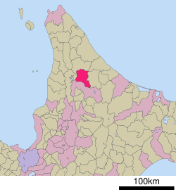
 Location of Nayoro in Hokkaido (Kamikawa Subprefecture) | |
| Coordinates: 44°21′21″N 142°27′48″E / 44.35583°N 142.46333°E | |
| Country | Japan |
| Region | Hokkaido |
| Prefecture | Hokkaido (Kamikawa Subprefecture) |
| Government | |
| • Mayor | Takeshi Kato |
| Area | |
• Total | 535.23 km2 (206.65 sq mi) |
| Population (September 2016) | |
• Total | 28,373 |
| • Density | 53/km2 (140/sq mi) |
| Time zone | UTC+09:00 (JST) |
| City hall address | 1-1 Ōdōri Minami, Nayoro-shi, Hokkaido 096-8686 |
| Climate | Dfb |
| Website | www |
| Symbols | |
| Bird | Great spotted woodpecker |
| Flower | Ōbana enreisō (Trillium kamtschaticum) |
| Mascot | Nayoro-kun (なよろう) |
| Tree | Japanese white birch |
Nayoro (名寄市, Nayoro-shi, Ainu: Nay Oro meaning "in the middle of the valley") is a city in Kamikawa Subprefecture, Hokkaido, Japan.
As of September 2016[update], the city has an estimated population of 28,373 and a population density of 53 persons per km2 (140 persons per sq. mi.). The total area is 535.23 km2 (206.65 sq mi).
On March 27, 2006, the town of Fūren was merged into Nayoro.


