Back نیوارک-آن-ترنت AZB Нюарк он Трент Bulgarian Newark-on-Trent CEB Newark-on-Trent Welsh Newark-on-Trent German Newark-on-Trent Esperanto Newark-on-Trent Spanish Newark-on-Trent Estonian Newark-on-Trent Basque نیوارک-آن-ترنت Persian
| Newark-on-Trent | |
|---|---|
| Town and civil parish | |
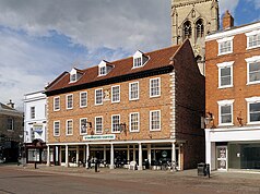
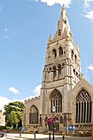
From the top, The former Moot Hall, Newark Castle, River Trent, St Mary Magdalene Church, Stodman Street Newark | |
 Parish map | |
Location within Nottinghamshire | |
| Area | 6.01 sq mi (15.6 km2) |
| Population | 30,345 (2021) |
| • Density | 5,049/sq mi (1,949/km2) |
| OS grid reference | SK 53745 61114 |
| • London | 140 mi (230 km) SSE |
| District | |
| Shire county | |
| Region | |
| Country | England |
| Sovereign state | United Kingdom |
| Areas of the town | List
|
| Post town | Newark |
| Postcode district | NG22–NG24 |
| Dialling code | 01636 |
| Police | Nottinghamshire |
| Fire | Nottinghamshire |
| Ambulance | East Midlands |
| UK Parliament | |
| Website | www |
Newark-on-Trent (/ˌnjuːərk -/)[1] or Newark[2] is a market town and civil parish in the Newark and Sherwood district in Nottinghamshire, England.[3] It is on the River Trent, and was historically a major inland port.[4] The A1 road bypasses the town on the line of the ancient Great North Road. The town's origins are likely to be Roman, as it lies on a major Roman road, the Fosse Way. It grew up around Newark Castle, St Mary Magdalene church and later developed as a centre for the wool and cloth trades.
In the English Civil War, it was besieged by Parliamentary forces and relieved by Royalist forces under Prince Rupert. Newark has a marketplace lined with many historical buildings and one of its most notable landmarks is St Mary Magdalene church with its towering spire at 232 feet (71 metres) high and the highest structure in the town. The church is the tallest church building in Nottinghamshire and can be seen when entering Newark or bypassing it.[5] The population of the town was recorded at 30,345 at the 2021 census.[6]

- ^ Collins Dictionary "Newark-on-Trent in British". collinsdictionary.com. Retrieved 12 July 2018.
- ^ "Newark - Visit Nottinghamshire". www.visit-nottinghamshire.co.uk. Retrieved 20 April 2023.
- ^ "Newark". Mapit. Archived from the original on 5 May 2018. Retrieved 10 February 2018.
- ^ "Newark". canalrivertrust.org.uk. Canal & River Trust. Retrieved 23 January 2022.
- ^ "History – St Mary Magdalene with St Leonard, Newark". Retrieved 23 January 2022.
- ^ Cite error: The named reference
:0was invoked but never defined (see the help page).


