Back مقاطعة نيز بيرس (أيداهو) Arabic Nez Perce County, Idaho BAR Нез Пърс (окръг) Bulgarian নেজ পেরসে কাউন্টি, আইডাহো BPY Nez Perce Gông (Idaho) CDO Нез-Перс (гуо, Айдахо) CE Nez Perce County CEB Nez Perce County, Idaho Welsh Nez Perce County German Condado de Nez Perce Spanish
Nez Perce County | |
|---|---|
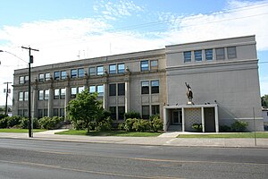
 Nez Perce County Courthouse in Lewiston, Idaho | |
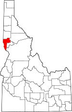
 Location within the U.S. state of Idaho | |
 Idaho's location within the U.S. | |
| Coordinates: 46°20′N 116°45′W / 46.33°N 116.75°W | |
| Country | |
| State | |
| Founded | February 4, 1864 |
| Named for | Nez Percé tribe |
| Seat | Lewiston |
| Largest city | Lewiston |
| Area | |
• Total | 856 sq mi (2,220 km2) |
| • Land | 848 sq mi (2,200 km2) |
| • Water | 8.2 sq mi (21 km2) 0.85% |
| Population (2020) | |
• Total | 42,090 |
| • Density | 49/sq mi (19/km2) |
| Time zone | UTC−8 (Pacific) |
| • Summer (DST) | UTC−7 (PDT) |
| Congressional district | 1st |
| Website | www |
Nez Perce County NEZZ-purse; is a county located in the U.S. state of Idaho. As of the 2020 United States census, the population was 42,090.[1] The county seat is Lewiston.[2] The county is named after the Native American Nez Perce tribe. Nez Perce County is part of the Lewiston, Idaho–WA Metropolitan Statistical Area.
- ^ Cite error: The named reference
2020 Censuswas invoked but never defined (see the help page). - ^ "Find a County". National Association of Counties. Retrieved June 7, 2011.