Back جزر نجيلا Arabic Islles Florida AST Inizi Nggela Breton Floridaøerne Danish Nggela German Islas Florida Spanish Nggela uharteak Basque جزایر نگگلا Persian Îles Florida French Illas Florida Galician
Native name: Nggela Sule and Nggela Pile | |
|---|---|
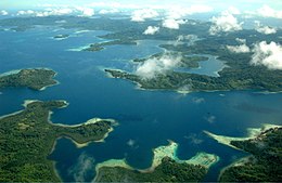
 The Nggela Islands from the air | |
 Map of the Nggela islands group | |
| Geography | |
| Location | South Pacific Ocean |
| Coordinates | 9°00′S 160°10′E / 9.000°S 160.167°E |
| Archipelago | Solomon Islands (archipelago) |
| Total islands | 4 |
| Major islands | 2 |
| Administration | |
| Province | Central Province |
The Nggela Islands or Ngella Islands,[1] previously known as the Florida Islands, are a small island group in the Central Province of Solomon Islands,[2] a sovereign state, since 1978, in the southwest Pacific Ocean. The name Florida Islands fell into disuse following Solomon Islands' independence in 1978.[2][3]
The group is composed of four larger islands and about 50 smaller ones, many with white coral beaches. The four main islands are, Nggela Sule with Nggela Pile to its southeast, separated by the narrow Mboli Passage, Olevugha (also known as Mobokonimbeti, and previously Sandfly Is.) and Vatilau (also known as Buenavista) to the northwest. Smaller islands include: Anuha, (70 ha (170 acres)), south of Nggela Sule, Tulagi just off the southwest coast of Nggela Sule, now the capital of Central Province and previously the British administrative centre for the Solomons, Gavutu and Tanambogo.[2][4][5][6]
- ^ "Central Province, Solomon Islands | Solomon Airlines". www.flysolomons.com. Retrieved 3 November 2024.
The Central Islands – made up of the Savo, Ngella (Florida) and Russell Islands
- ^ a b c Larson, Thomas J. (2003). "The Geography of Guadalcanal, Savo, Florida And Telugu". Hell's Kitchen Tulagi 1942–1943. iUniverse. p. 25. ISBN 9780595277568.
- ^ "A Guide to the United States' History of Recognition, Diplomatic, and Consular Relations, by Country, since 1776: The Solomon Islands". history.state.gov. Office of The Historian, US Department of State. Retrieved 27 July 2017.
- ^ Macdonald, Ian (16 March 2013). "Central Province (Solomon Islands)". CRWFlags.com. Retrieved 27 July 2017.
- ^ Macdonald, Ian (3 December 2010). "Provincial Flags (Solomon Islands)". CRWFlags.com. Retrieved 27 July 2017.
- ^ "Geographic Names: Sandfly Passage: Solomon Islands". geographic.org. Bethesda, Maryland: National Geospatial-Intelligence Agency. Retrieved 27 July 2017.
