Back Normandie ALS Normandía AN نرمندية (منطقة إدارية) Arabic Normandía AST Нармандыя (рэгіён) Byelorussian Нормандия (регион) Bulgarian Normandi (rannvro) Breton Normandia (regió administrativa) Catalan Normandie (region) Czech Normandie Danish
Normandy
| |
|---|---|
 | |
 | |
| Coordinates: 48°53′N 0°10′E / 48.88°N 0.17°E | |
| Country | |
| Regional council seat | Caen |
| Prefecture | Rouen |
| Departments | 5
|
| Government | |
| • President of the Regional Council | Hervé Morin (LC) |
| Area | |
• Total | 29,906 km2 (11,547 sq mi) |
| • Rank | 11th |
| Population (2022)[1] | |
• Total | 3,339,074 |
| • Density | 110/km2 (290/sq mi) |
| Demonym | Norman[2] |
| GDP | |
| • Total | €99.315 billion |
| • Per capita | €29,900 |
| Time zone | UTC+01:00 (CET) |
| • Summer (DST) | UTC+02:00 (CEST) |
| ISO 3166 code | FR-NOR |
| NUTS Region | FRD |
| Website | www |
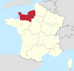
Normandy (/ˈnɔːrməndi/ NOR-mən-dee; French: Normandie [nɔʁmɑ̃di] ⓘ; Norman: Normaundie) is the northwesternmost of the eighteen regions of France, roughly coextensive with the historical Duchy of Normandy.
Normandy is divided into five administrative departments: Calvados, Eure, Manche, Orne and Seine-Maritime. It covers 30,627 square kilometres (11,825 sq mi),[4] comprising roughly 5% of the territory of metropolitan France. Its population of 3,322,757 accounts for around 5% of the population of France. The inhabitants of Normandy are known as Normans, and the region is the historic homeland of the Norman language. The neighboring regions are Hauts-de-France and Ile-de-France to the east, Centre-Val de Loire to the southeast, Pays de la Loire to the south, and Brittany to the southwest. Its prefecture and largest city is Rouen, although the regional council sits in Caen, making Normandy one of two regions in France (along with Bourgogne-Franche-Comté) in which the prefect does not sit in the same city as the regional council.
Normandy's name comes from the settlement of the territory by Vikings ("Northmen") from the 9th century, and confirmed by treaty in the 10th century between King Charles III of France and the Viking jarl Rollo.
- ^ "Populations de référence 2022" (in French). The National Institute of Statistics and Economic Studies. 19 December 2024.
- ^ "Norman". WordReference.com. Retrieved 23 April 2016.
3. a native or inhabitant of Normandy
- ^ "EU regions by GDP, Eurostat". Retrieved 18 September 2023.
- ^ Administrative Normandy Archived 1 May 2008 at the Wayback Machine

