Back Şimali Macar dağları Azerbaijani Severomaďarské středohoří Czech Nordungarske bjerge Danish Nördliches Ungarisches Mittelgebirge German Norda Mezmontaro Esperanto Montañas del Norte de Hungría Spanish Põhja-Ungari keskmäestik Estonian Massif du Nord (Hongrie) French Északi-középhegység Hungarian Rilievi precarpatici settentrionali Italian
| North Hungarian Mountains | |
|---|---|
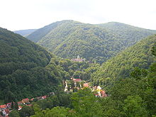
 The view of the valley of Lillafüred in the Bükk mountains. Although this is not the highest part of the county, the landscape is typical of Hungarian mountains. | |
| Location | Northern Hungary, southern Slovakia |
| Territory | 13,000 km2 (in Hungary) |
| Highest point | Kékes (Hungary) 1014 m Šimonka (Slovakia) 1092 m |
| Terrain | lower and moderately high mountains |

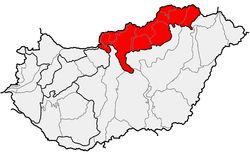
The North Hungarian Mountains (Hungarian: Északi-középhegység), sometimes also referred to as the Northeast Hungarian Mountains, Northeast Mountains, North Hungarian Highlands, North Hungarian Mid-Mountains or North Hungarian Range,[1][2] is the northern, mountainous part of Hungary. It forms a geographical unity with the Mátra-Slanec Area, the adjacent parts of Slovakia. It is a separate geomorphological area within the Western Carpathians.
The mountains run along the northeastern border of Hungary as well as eastern parts of the Hungarian–Slovak border in broadband from the Danube Bend to the town of Prešov.
- ^ Gábor Gercsák (2002). "Hungarian geographical names in English language publications" (PDF). Studia Cartologica. Eötvös Loránd University. Archived from the original (PDF) on 20 March 2012. Retrieved 30 April 2011.
- ^ Gábor Gercsák (2005). "Magyar tájnevek Angol fordítása" (PDF). Fasciculi Linguistici / Series Lexicographica (in Hungarian). Eötvös Loránd University. Archived from the original (PDF) on 20 March 2012. Retrieved 30 April 2011.