Back نورث هيفن (كونيتيكت) Arabic North Haven (Connecticut) Catalan Норт-Гейвен (Коннектикут) CE North Haven (lungsod sa Tinipong Bansa, Connecticut) CEB North Haven, Connecticut Welsh North Haven (Connecticut) German North Haven (Connecticut) Spanish North Haven (Connecticut) Basque North Haven (Connecticut) French North Haven, Connecticut HT
North Haven, Connecticut | |
|---|---|
| Town of North Haven | |
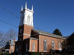
 St. John's Episcopal Church, built in 1834 | |
| Coordinates: 41°22′54″N 72°51′30″W / 41.38167°N 72.85833°W | |
| Country | |
| U.S. state | |
| County | New Haven |
| Region | South Central CT |
| Incorporated | 1786 |
| Government | |
| • Type | Selectman-town meeting |
| • First Selectman | Michael Freda (R) |
| • Selectman | William J. Pieper (R) |
| • Selectman | Sally Buemi (D) |
| Area | |
• Total | 21.1 sq mi (54.6 km2) |
| • Land | 20.8 sq mi (53.8 km2) |
| • Water | 0.3 sq mi (0.8 km2) |
| Elevation | 66 ft (20 m) |
| Population (2020) | |
• Total | 24,253 |
| • Density | 1,100/sq mi (440/km2) |
| Time zone | UTC−5 (Eastern) |
| • Summer (DST) | UTC−4 (Eastern) |
| ZIP Code | 06473 |
| Area code(s) | 203/475 |
| FIPS code | 09-54870 |
| GNIS feature ID | 0213479 |
| Major highways | |
| Website | www |
North Haven is a town in New Haven County, Connecticut, United States on the outskirts of New Haven. The town is part of the South Central Connecticut Planning Region. As of the 2020 census, it had a population of 24,253.[1]
North Haven is home of the Quinnipiac University School of Health Sciences, the School of Nursing, School of Law, School of Education, and School of Medicine on Bassett Road.[2][3] North Haven has easy access to Interstate 91 and the Wilbur Cross Parkway (Route 15). It is near Sleeping Giant State Park and less than 10 miles (16 km) from downtown New Haven and Yale University.
- ^ "Census - Geography Profile: North Haven, New Haven County, Connecticut". United States Census Bureau. Retrieved December 18, 2021.
- ^ "North Haven Campus". Quinniapiac University. Archived from the original on November 22, 2011. Retrieved December 1, 2011.
- ^ "North Haven Campus Map" (PDF) (Annotated map). Quinnipiac University. Retrieved December 12, 2020.


