Back Noordeiland Afrikaans Isla d'o Norte AN Norþīg ANG الجزيرة الشمالية (نيوزيلندا) Arabic لݣزيرة دالشمال ARY الجزيره الشماليه ARZ Islla Norte AST Şimal adası (Yeni Zelandiya) Azerbaijani Төньяҡ утрау (Яңы Зеландия) Bashkir Nusa Kalér BAN
Te Ika-a-Māui (Māori) | |
|---|---|
 | |
| Geography | |
| Location | Oceania |
| Coordinates | 39°S 176°E / 39°S 176°E |
| Archipelago | New Zealand |
| Major islands | North Island |
| Area | 113,729 km2 (43,911 sq mi) |
| Area rank | 14th |
| Highest elevation | 2,797 m (9177 ft) |
| Highest point | Mount Ruapehu |
| Administration | |
New Zealand | |
| Regions | 9 |
| Territorial authorities | 43 |
| Largest settlement | Auckland (pop. 1,531,400) |
| Demographics | |
| Demonym | North Islander |
| Population | 4,077,800 (June 2024) |
| Pop. density | 35.9/km2 (93/sq mi) |
| Ethnic groups | European (63.1%), Māori (19.8%), Asian (19.3%), Pacific peoples (10.6%) |
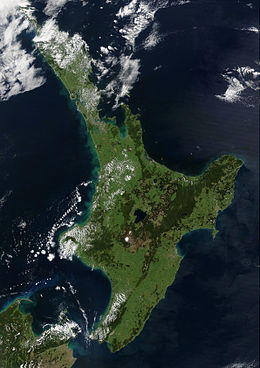
The North Island (Māori: Te Ika-a-Māui [tɛ i.kɐ ɐ mɑː.ʉ.i], lit. 'the fish of Māui', officially North Island or Te Ika-a-Māui or historically New Ulster) is one of the two main islands of New Zealand, separated from the larger but less populous South Island by Cook Strait. With an area of 113,729 km2 (43,911 sq mi),[1] it is the world's 14th-largest island, constituting 43% of New Zealand's land area. It has a population of 4,077,800 (June 2024),[2] which is 76% of New Zealand's residents,[3] making it the most populous island in Polynesia and the 28th-most-populous island in the world.
Twelve main urban areas (half of them officially cities) are in the North Island. From north to south, they are Whangārei, Auckland, Hamilton, Tauranga, Rotorua, Gisborne, New Plymouth, Napier, Hastings, Whanganui, Palmerston North, and New Zealand's capital city Wellington, which is located at the south-west tip of the island.
- ^ "Quick Facts – Land and Environment : Geography – Physical Features". Statistics New Zealand. 2000. Archived from the original on 8 April 2013. Retrieved 13 August 2012.
- ^ "Aotearoa Data Explorer". Statistics New Zealand. Retrieved 26 October 2024.
- ^ "77% of NZers live in North Island". RNZ. 26 October 2017. Retrieved 19 November 2021.
