Back Riding Gogleddol Swydd Efrog Welsh North Riding of Yorkshire German North Riding of Yorkshire French North Riding of Yorkshire Italian North Riding of Yorkshire Polish North Riding of Yorkshire SIMPLE North Riding of Yorkshire Swedish
| County of York, North Riding | |
|---|---|
 Flag of North Riding (2013) | |
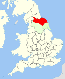
 North Riding shown within England | |
| Area | |
| • 1911 | 1,359,600 acres (5,502 km2) |
| • 1961 | 1,376,607 acres (5,570.93 km2) |
| Population | |
| • 1901 | 286,036 |
| • 1971 | 329,410 |
| History | |
| • Created | Ancient (as a county in 1889) |
| • Abolished | 1974 |
| • Succeeded by |
|
| Status | Riding then Administrative county |
| Chapman code | NRY |
| Government | North Riding County Council (1889–1974) |
| • HQ | Northallerton |
 Coat of arms of North Riding County Council | |
The North Riding of Yorkshire was a subdivision of Yorkshire, England, alongside York, the East Riding and West Riding. The riding's highest point was at Mickle Fell at 2,585 ft (788 m).
From the Restoration it was used as a lieutenancy area, having been previously part of the Yorkshire lieutenancy. Each riding was treated as a county for many purposes, such as quarter sessions. An administrative county, based on the riding, was created with a county council in 1889 under the Local Government Act 1888. In 1974 both the administrative county and the North Riding of Yorkshire lieutenancy were abolished, replaced in most of the riding by the non-metropolitan county and lieutenancy of North Yorkshire, and in the north-west by County Durham.