Back نورث ستونينغتون (كونيتيكت) Arabic نورث ستونينجتون ARZ North Stonington Catalan Норт-Стонингтон (Коннектикут) CE North Stonington, Connecticut Welsh North Stonington Spanish North Stonington (Connecticut) Basque North Stonington French North Stonington, Connecticut HT North Stonington Hungarian
This article needs additional citations for verification. (January 2017) |
North Stonington, Connecticut | |
|---|---|
Town | |
| Town of North Stonington | |
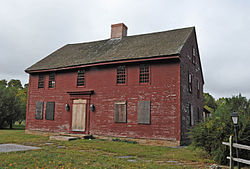
 John Randall House, built in 1690 | |
| Coordinates: 41°28′N 71°52′W / 41.467°N 71.867°W | |
| Country | |
| U.S. state | |
| County | New London |
| Region | Southeastern CT |
| Incorporated | 1807[1] |
| Government | |
| • Type | Selectman-town meeting |
| • First selectman | Robert Carlson (R)[2] |
| • Selectman | Brett Mastroianni (R) |
| • Selectman | Nichole Porter (D) |
| Area | |
• Total | 55.0 sq mi (142.4 km2) |
| • Land | 54.3 sq mi (140.7 km2) |
| • Water | 0.7 sq mi (1.7 km2) |
| Elevation | 384 ft (117 m) |
| Population (2020)[3] | |
• Total | 5,149 |
| • Density | 94/sq mi (36/km2) |
| Time zone | UTC−5 (Eastern) |
| • Summer (DST) | UTC−4 (Eastern) |
| ZIP Code | 06359 |
| Area code(s) | 860/959 |
| FIPS code | 09-55500 |
| GNIS feature ID | 0213480 |
| Website | www |
North Stonington is a town in New London County, Connecticut, United States which was split off from Stonington in 1724. The town is part of the Southeastern Connecticut Planning Region. The population was 5,149 at the 2020 census.[3]
- ^ The Connecticut Magazine: An Illustrated Monthly. Connecticut Magazine Company. 1903. p. 333.
- ^ "Board of Selectmen". Town of North Stonington, CT. Retrieved September 16, 2015.
- ^ a b "Census - Geography Profile: North Stonington town, New London County, Connecticut". United States Census Bureau. Retrieved December 18, 2021.


