Back أوكراكوك (كارولاينا الشمالية) Arabic Ocracoke Catalan Окракок (Къилбаседа Каролина) CE Ocracoke CEB Ocracoke (Carolina del Norte) Spanish Ocracoke (Ipar Carolina) Basque وکراکوک، کارولینای شمالی Persian Ocracoke Finnish Ocracoke (Caroline du Nord) French اوکراکوک (کلسيايي کارؤلینا) GLK
Ocracoke | |
|---|---|
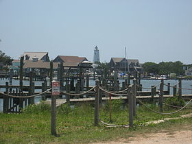
 Ocracoke Lighthouse seen from Ocracoke Harbor | |
| Coordinates: 35°6′46″N 75°58′33″W / 35.11278°N 75.97583°W | |
| Country | |
| State | |
| County | Hyde |
| Named for | Ocracoke Inlet |
| Area | |
• Total | 9.62 sq mi (24.91 km2) |
| • Land | 8.60 sq mi (22.27 km2) |
| • Water | 1.02 sq mi (2.64 km2) |
| Elevation | 3 ft (1 m) |
| Population (2020) | |
• Total | 797 |
| • Density | 92.69/sq mi (35.79/km2) |
| Time zone | UTC−05:00 (Eastern (EST)) |
| • Summer (DST) | UTC−04:00 (EDT) |
| ZIP Code | 27960 |
| Area code | 252 |
| FIPS code | 37-48740[3] |
| GNIS feature ID | 1021718[2] |
| Demonym | Ococker |
| Website | visitocracokenc |
Ocracoke (/ˈoʊkrəkoʊk/ OH-krə-kohk)[4][5] is a census-designated place (CDP) and unincorporated town located at the southern end of Ocracoke Island, within Hyde County, North Carolina. The population was 948 at the 2010 census.[6] In the 2020 census, the population had dropped to 797.[7]
No bridges connect Ocracoke Island to the mainland, though the main road across the island is part of North Carolina Highway 12, which uses a series of ferries to connect to Hatteras Island, to Cedar Island, and to the mainland at Swan Quarter. The economy of the island is driven by tourism and commercial fishing. A unique dialect of English, known colloquially as the Hoi Toider accent, is spoken in Ocracoke, though among younger residents it is being replaced by more standard dialects of General American. Ocracoke Island was the location of the pirate Blackbeard's death in November 1718.[8][9][10][11][12] Though it saw no direct military action, Ocracoke was the site of a Confederate fort during the U.S. Civil War. During World War II, German submarines torpedoed several British ships off the coast of the island; the remains of four sailors washed ashore and occupy a small cemetery on the island.[13] There is a yearly ceremony to honor the British dead presented by the British government, the National Park Service, and the United States Coast Guard.[14]
Being so far out in the Atlantic Ocean, Ocracoke Island is frequently in the path of tropical cyclones, notably Hurricane Dorian in 2019, which destroyed approximately 1,000 feet (300 m) of pavement along NC 12.
- ^ "ArcGIS REST Services Directory". United States Census Bureau. Retrieved September 20, 2022.
- ^ a b U.S. Geological Survey Geographic Names Information System: Ocracoke, North Carolina
- ^ "U.S. Census website". United States Census Bureau. Retrieved January 31, 2008.
- ^ "NC Pronunciation Guide". WRAL. Retrieved August 15, 2022.
- ^ Talk Like a Tarheel Archived 2013-06-22 at the Wayback Machine, from the North Carolina Collection website at the University of North Carolina at Chapel Hill. Retrieved 2013-01-29.
- ^ "Geographic Identifiers: 2010 Census Summary File 1 (G001): Ocracoke CDP, North Carolina". American Factfinder. U.S. Census Bureau. Archived from the original on February 13, 2020. Retrieved December 22, 2017.
- ^ "Explore Census Data". data.census.gov. Retrieved December 20, 2021.
- ^ "Ocracoke's Most Famous Visitor". nps.gov. Retrieved June 1, 2013.
- ^ "Blackbeard the Pirate". ocracokeweb.com. Archived from the original on May 19, 2013. Retrieved June 1, 2013.
- ^ "Ocracoke Island, North Carolina: A Research Guide". University of North Carolina Library. Archived from the original on August 27, 2013. Retrieved June 1, 2013.
- ^ Konstam, Angus (2006). Blackbeard: America's Most Notorious Pirate. John Wiley & Sons. p. 336. ISBN 0-471-75885-X.
- ^ John Amrhein. "Ocracoke, North Carolina". treasureislandtheuntoldstory.com. Retrieved June 2, 2013.
- ^ Cite error: The named reference
brit_ocracokewas invoked but never defined (see the help page). - ^ "Ocracoke British Cemetery". Retrieved June 10, 2024.
