Back اوییو چایی AZB Oglio BAR Олья Byelorussian Ольо Bulgarian Oglio Breton Oglio Catalan Fiume Oglio CEB Oglio Czech Ольо CV Oglio German
| Oglio | |
|---|---|
 | |
 Course of the river Oglio | |
| Native name | Òi / Ùi (Lombard) |
| Location | |
| country | Italy |
| region | Lombardy |
| provinces | Brescia, Bergamo, Cremona, Mantua |
| Physical characteristics | |
| Source | Valle delle Messi, as Frigidolfo branch |
| • location | near Punta Valmalza, Sobretta-Gavia Group, Ortler Alps, Lombardy |
| • coordinates | 46°20′31.5″N 10°27′03.5″E / 46.342083°N 10.450972°E |
| • elevation | 3,035 m (9,957 ft) |
| 2nd source | Lake Ercavallo, Valle di Viso, as Arcanello branch |
| • location | at the slopes of Cima di Caione, Ortler Alps, Lombardy |
| • coordinates | 46°20′21.1″N 10°31′35.5″E / 46.339194°N 10.526528°E |
| • elevation | 2,621 m (8,599 ft) |
| 3rd source | Lake Pisgana, as Narcanello branch |
| • location | Narcanello Valley, near Vedretta di Pisgana, Presena glacier, Adamello-Presanella Alps, Lombardy |
| • coordinates | 46°12′22″N 10°31′49″E / 46.20611°N 10.53028°E |
| • elevation | 2,500 m (8,200 ft) |
| 4th source | Ogliolo branch |
| • location | Corteno Valley, on the provincial border between Corteno Golgi, province of Brescia and Aprica, province of Sondrio, Lombardy, near Zappello dell'Asino |
| • coordinates | 46°08′52″N 10°09′54.2″E / 46.14778°N 10.165056°E |
| • elevation | 1,172 m (3,845 ft) |
| Source confluence | confluence of Frigidolfo and Narcanello branches |
| • location | Ponte di Legno, province of Brescia, Lombardy |
| • coordinates | 46°15′32.7″N 10°30′28.7″E / 46.259083°N 10.507972°E |
| • elevation | 1,253 m (4,111 ft) |
| Mouth | Po |
• location | at the municipal border between Marcaria and Viadana, province of Mantua, Lombardy |
• coordinates | 45°02′40″N 10°39′37″E / 45.04444°N 10.66028°E |
| Length | 280 km (170 mi) |
| Basin size | 6,649 km2 (2,567 sq mi) |
| Discharge | |
| • average | 137 m3/s (4,800 cu ft/s) |
| Basin features | |
| Progression | Po→ Adriatic Sea |


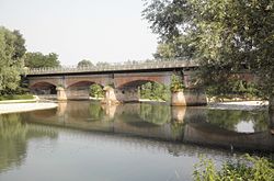
The Oglio (Italian: [ˈɔʎʎo]; Latin: Ollius or Olius; Lombard: Òi, Cremonese: Ùi) is a left-side tributary of the river Po in Lombardy, Italy. It is 280 kilometres (170 mi) long. In the hierarchy of the Po's tributaries, with its 280 kilometres (170 mi) of length, it occupies the 2nd place per length (after the river Adda), while it is the 4th per basin surface (after Tanaro, Adda and Ticino), and the 3rd per average discharge at the mouth (after Ticino and Adda).