Back القناه الجانبيه فى الواحه ARZ Canal Latéral à l'Oise CEB Canal latéral à l’Oise German Canal latéral à l'Oise French Canal latéral à l'Oise Dutch 瓦兹河旁侧运河 Chinese
| Canal latéral à l'Oise | |
|---|---|
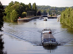
 Lock on the Oise at L'Isle-Adam, Val-d'Oise, France | |
 | |
| Specifications | |
| Length | 34 km (21 mi) |
| Lock length | 39 m (128 ft) |
| Lock width | 6.50 m (21.3 ft) |
| Locks | 4 |
| Status | Open |
| History | |
| Date completed | 1831 |
| Geography | |
| Start point | Canal de Saint-Quentin at Chauny |
| End point | Oise at Janville |
| Beginning coordinates | 49°36′15″N 3°13′13″E / 49.60417°N 3.22033°E |
| Ending coordinates | 49°27′27″N 3°51′34″E / 49.45750°N 3.85933°E |
| Connects to | Canal de Saint-Quentin, Canal du Nord, River Oise |
The Canal latéral à l'Oise (French pronunciation: [kanal lateʁal a lwaz]) is a canal in northern France that, along with the river Oise, connects the Canal de Saint-Quentin at Chauny to the Seine at Conflans-Sainte-Honorine.[1] See under the river Oise for the continuation of the route; the junction is made downstream of the lock at Janville 49°27′27″N 2°51′34″E / 49.45750°N 2.85933°E. When a canal is latéral (literally 'running beside'), it follows the course of the river it is named after but in a separate excavated channel. The route described below is the 34 km of canal parallel to the river Oise and 103.5 km of the canalised river Oise.
- ^ Jefferson, David (2009). Through the French Canals. Adlard Coles Nautical. pp. 14, 111–112. ISBN 978-1-4081-0381-4.